

Oh, the land of simple love!
A land that stands out among the hills,
With the scent of rosemary and thyme,
Myrtle, wild crab apple, and basil.
Oh, this land of countless sown fields!
Walled with stone and old lichen,
Where man and ox, an eternal yoke,
In the desolate summer days,
Gazing at the high blue sky, like a mirror,
Pondering questions from the furrow.
Excerpt from Cantos de sur y norte (1954)
Manuel Felipe Rugeles, Tachiran poet, 1903-1959.
English translation (with no English versification): Samir A. Sánchez, 2014.
Esta es la tierra del amor sencillo,
tierra que entre colinas se destaca,
con su olor a romero y a tomillo,
a arrayán, pomarrosa y albahaca.
Esta es la tierra de los mil sembrados
y los cercos de piedra y limo viejo,
donde el hombre y el buey -eternas yuntas-
en días de verano desolados,
mirando al cielo azul, como un espejo,
desde el surco lo llenan de preguntas.
Cantos de sur y norte (1954, fragmento).
Manuel Felipe Rugeles (poeta tachirense, 1903-1959)
Táchira State Facts & History
Safeguard and promotion of Tachiran heritage and culture
Estado Táchira, Spanish Official name
Gateway to The Andes
Written by Samir A. Sánchez (2015)
Táchira State Historian
For Spanish-speaking World (2014)
Honour your Millennial Tachiran Heritage, Our Heritage Land...
Táchira [IPA: ‘tatʃiɾa], The State's name is derived from a Native American agglutinative language, the Muisca, namely, from a compose word: Ta [tillage], Chi [our] and Ra [element modifying used as present continuous particle form or future], meaning "Our Heritage Land".
In Memory of my Most Loved Father, Simeón Alner Sánchez Sandoval (San Cristóbal August 3, 1939 - San Cristóbal February 10, 2023). His very wise spirit, his showed humanity, charities, his words of encouragement, and his love for the Tachiran land he loved most of all lands are always with me.


Literacy rate: 89.9 percent (2011 estimate).
.jpg)
.jpg)
.jpg)
.jpg)
.jpg)
.jpg)
Largest Municipality: Uribante (1,502 km2/579.93 sq mi).
Foreing communities in Táchira State: Colombian, Spanish, Italian, Portuguese, Syrian, Peruvian, Ecuadoran, Chinese, Lebanese, Japanese, German, Greek and Jewish or Hebrew (Eastern Europe).

Introduction
From San Cristóbal City, our gracious capital nestled in the Santiago Valley, at the very foot of the majestic Sierra de la Maravilla, I extend my warmest greetings to the reader of this overview. I invite you to embark on a journey—a grand tour, if you will—through our ancient land and enterprising State of Táchira. This territory truly is a country unto itself, linking a noble past—for from the earliest times, the land of Táchira has left its indelible mark upon the pages of history—with our meaningful present.
A Land of Green and Grandeur
From the crags of the highest, misty Andean peaks to the luxuriant tropical forests of the Lake Maracaibo lowlands; from the sun-drenched borderlands to the superb summits of Uribante; from the rolling hills of the south to the lower mountains of the inland Táchira Depression, Táchira State presents a truly inexhaustible kaleidoscope of views and vistas.
When one truly contemplates Táchira, one invariably conjures up images of its industrious highlanders, verdant landscapes, perpetual mist, the evocative aroma of coffee, and the lonely, myth-rich kettle lakes of the Andes. It is a region renowned as the birthplace of presidents, home to a formidable gold and black football/soccer team, and a land where the traditions of the ox & plough meet a vigorous entrepreneurial spirit and magnificent scenery.
All of these elements form the rich fabric of this unique territory, capturing the very essence of Tachiran culture in its forms, words, and symbols. Táchira lends itself to exploration in countless ways, each offering an adventure of discovery rich in unforgettable experiences—though a modest grasp of Spanish and a reliable cagoule (rain jacket) may be prudent additions to one's packing.
The Frontiersmen: Identity and Hospitality
There are compelling reasons why Táchira State stands apart. The Frontiersmen, the Tachiran people, habitually use the definite article before the noun—'el Táchira'—to emphasise that they refer to this land as the singular, unique entity it is. It is far more than merely a state; it is a cultural homeland.
This sense of distinctiveness is matched by a timeless hospitality. As a gesture of friendship and welcome, when one visits our homeland, one will invariably be offered 'un cafecito', a small cup of black, thick Tachiran coffee. It is, quite simply, the finest coffee in the world.
The Venezuelan Basques
The State of Táchira, through its resourceful populace, has long thrived as a commercial and agricultural hub while resolutely maintaining a unique regional identity. It is for this reason that, drawing upon ethnographic analogy, the Tachiran people are affectionately known as ‘the Basques of Venezuela’. This appellation is earned by their indomitable, transcendent spirit and fierce pride in their freedom, their deep-seated love for their own ancient mountains, and their renowned dedication to hard work. It was this entrepreneurial, resolute, and courageous spirit that enabled Táchira to lead and define the trajectory of an entire nation.
An Invitation
In sum, we extend this invitation to acquaint yourself with this land through these essential facts. Observe what has been accomplished and the vast potential that lies ahead.
Two colours will be your constant companions on your journey through Táchira: the emerald of the majestic setting of its mountains, hills, shires, and valleys, and the deep blue of its sky.
We are delighted to welcome you to the State of Táchira and invite you to witness its achievements for yourself. It is with great pleasure that we extend the traditional Tachiran greeting: '¡Bienvenidos al país tachirense, al país de los tachirenses, esta es su casa!' (Welcome to the Tachiran country, the country of the Tachirans, this is your home!).
Samir A. SánchezEl Remanso de Santiago Estate, from the misty wooded slopes of the 'Sierra de la Maravilla' range, San Cristóbal City, January 2015.
 |
The State of Táchira. (Encarta, Microsoft 2009, image for educational purposes. 2014) |
Geographic location: Táchira, one of the landlocked West States of Venezuela, northern South America. The old Tierra Firme-The Spanish Main. The Andes Mountains is major geographical feature of Táchira and it is bordered on the west by de Colombian Department of ‘Norte de Santander’ or Northern Santander.
 |
The Ancient Venezuela... Tierra de Gracia/Graceland, the Earthly Paradise: the Spanish Main or 'Tierra Firme'. Columbus here believed that he had found the Garden of Eden, in 1498. The Spanish possessions in the West Indies, Venezuelan, Colombian, Guianan, Central American and Mexican coast. ‘Terra Firma, Guiana and the Antilles Islands’ by H. Moll, Geographer, 1732. Special tear-out old map, El Universal Newspaper, Caracas, September, 2004, image for educational purposes. |
Total area: 11,100 sq. km/4,284 sq. mi (slightly larger than Jamaica). Táchira State has the shape -metaphorical- of piel de toro-bull's hide.
Boundaries: the state lines are Zulia State on the northern; Apure and Barinas States and border country with Republic of Colombia to the S; Mérida and Barinas States to the E; Zulia State and Northern Santander Department (Colombia) to the W.
 |
Young Boy Tachiran Highland and his natural landscape. In the background 'el valle de San Bartolomé' (Spanish for Saint Bartholomew Valley) and El Cobre Town standing at 1,924 m a. s. l. or 6,313 ft. (Photograph by Juan Alberto Sánchez, 2017) |
Extreme points of the Táchira State: Northernmost point is located at the confluence of the Grande and Escalante rivers (Panamericano Municipality); Southernmost point is located at the confluence of the Burgua River and Los Pensamientos stream (Fernández Feo Municipality); Easternmost point is located at the confluence of the Doradas (Old channel) and Caparo rivers (Libertador Municipality); Westernmost point is located at the east bank of the Táchira River in front of Cerrito Hill, Sabana Larga hamlet (Pedro María Ureña Municipality). Táchira State has an extreme length from north to south of about 147.88 km/91.88 mi and maximum width from east to west of about 129.03 km/80.18 mi.
Superlative Statistics for the 29 Tachiran
Municipalities:
Northernmost city: Coloncito (Panamericano)
Northernmost town: La Tendida (Samuel Darío Maldonado)
Northernmost settlement: Puerto Escalante (Panamericano)
Southernmost city: San Rafael del Piñal (Fernández Feo)
Southernmost town: San Vicente de la Revancha (Junín)
Southernmost settlement: Burgua Arriba (Fernández Feo)
Easternmost city: Abejales (Libertador)
Easternmost town: El Milagro (Libertador)
Easternmost settlement: San Antonio de Caparo (Libertador)
Westernmost city: Ureña (Pedro María Ureña)
Westernmost town: Delicias (Rafael Urdaneta)
Westernmost settlement: Tabor (Rafael Urdaneta)
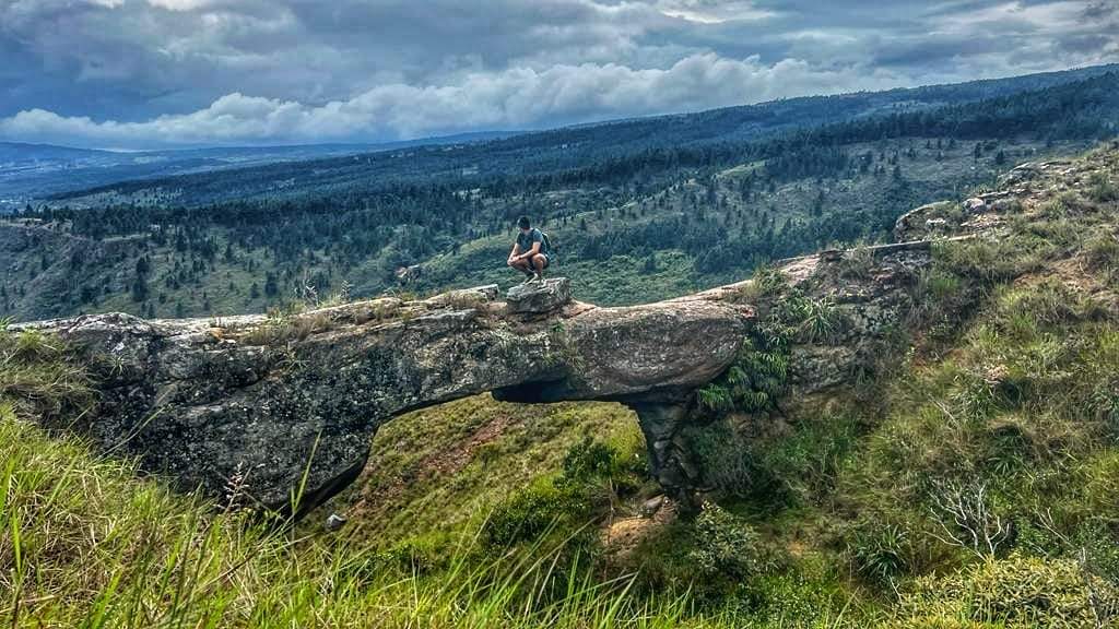
Táchira State is a landscape of contrasting colors, natural forms, and textures unlike any other. Natural stone arche or bridge called “El Puente del Diablo” [The Devil’s Bridge] at one point named Minas de Carbón de Lobatera, in Lobatera Municipality. Photograph by José Manuel Vera (2023).

Táchira State is a landscape of contrasting colors, natural forms, and textures unlike any other. Natural slot and cave by underground erosion called “Fosa-Cueva del Oído” [Ear Cave] at one point named Minas de Carbón de Lobatera, in Lobatera Municipality. Photograph by José Manuel Vera (2023).
First permanent settlement by Europeans: San Cristóbal City, settled Mar. 31, 1561.
 |
Reminders of a Bygone Age... From the earliest mists of antiquity the First Tachiran Art or Tachiran Indian Art. A way of looking at and representing the world. 'Escrituras Ancestrales' or Ancestral Scripture (patinated iron, 110 x 400 x 25 cm or 43 5/16 x 157 31/64 x 9 27/32 in) by Carlos Cruz Acero, Tachiran sculptor, known for his cast and forged iron works. Museum of Anthropology in San Cristóbal or ‘Museo del Táchira’. Natural Sciences building, entrance room. Photograph by Santiago Xavier Sánchez. (February 7, 2015) |
Time Zone: Venezuelan Standar Time (VET) or UTC (-04:00 time zone America/Caracas).
Táchira State UTM zones: 18P and 19P
Population: 1,168,908 (2011, Venezuela's Official Statistics Office). Note: Since the 2011 national census—the last to adhere to established protocols of data collection and dissemination—Venezuela has faced a dearth of official statistics. In the absence of contemporary state data, prevailing demographic insights are derived from the prognostications of multilateral organisations and scholarly studies.
Population density: 105, 3 persons per sq km / 272.2 persons per sq mi (2011 estimate).
Venezuelan rank: 5 (2011).
Urban population distribution: 77 percent (2011 estimate).
Rural population distribution: 23 percent (2011 estimate).
Life expectancy: 79.9 years (2011 estimate).
Population by Age: under 15 years: 24.9%; under 65 years: 68.3%; 65 years and over: 6.8% (2011 estimate).
Population by Age: under 15 years: 24.9%; under 65 years: 68.3%; 65 years and over: 6.8% (2011 estimate).
Antipodes: The point on the
earth's surface that is located on the globe diametrically opposite to the Táchira
State, and joined with an imaginary straight line that passes through the
centre of the earth and 180° of longitude, between the two points, is on a large expanse of salt water (11,100 sq km/4,284 sq. mi) of the surface of Indian Ocean, in
the Java Trench (7,125 m/23,375.98 ft), southwestern Sunda Strait between Java and Sumatra,
in Indonesia. Not far off in space, the night of August 26-27, 1883, Krakatoa
(Krakatau) Island (now Ujung Kulon National Park) was destroyed by a volcanic
eruption and an explosion in the eruption series produced one of the loudest
noises in history and it was heard at a distance of 4,800 km (3,000 mi).
Demonym or Name for Residents: Tachiran (Adjective, of Táchira State: relating to Táchira State, or its people, accent or culture. Plural: Tachirans). [Français: Tachirien; Deutsch: Tachiranisch]. Tachiranness (uncountable), the quality or state of being Tachiran (of or pertaining to Táchira State), our way of being, which identifies us. The Royal Spanish Academy introduced and incorporated the word 'tachirense' into the Dictionary of the Spanish Language, since 1967.
 |
The blue skies over San Cristóbal, Capital City of the Táchira State. It’s defined by imposing monuments and buildings – including the iconic ones that house the state government’s three branches: the ‘Palacio de los Leones’ (Táchira State Capitol),The ‘Residencia de Gobernadores’ (Official Residence of the Governor) and the ‘Edificio Nacional’ (State Supreme Court). Photograph by Tochadas.net.ve #DomingoDeRT, 2017. |
Capital: The state's largest city and capital is San Cristóbal [IPA: saŋ kɾis’toβal]. Seat of San Cristóbal Municipalitiy, the city is located along the Torbes River [Ancient Tormes. The Torbes River is a red river. The red coloring is the result of red sandstone full of iron oxide from La Machirí ranges. This mineral-rich sedimentary rock gets washed off the hillsides and mountains when it rains and turns the water a distinct red or pink hue and the colour tone depends on the volume of precipitation and sediments]. The city is perched upon the hills -on a series of steep hills- of Santiago Valley. Its historical and official name is Villa de San Cristóbal - Royal Town of Saint Christopher. The Spanish Conquistador Juan Maldonado y Ordóñez de Villaquirán erected the city on Monday, 31 March 1561 (O. S.) to the southern end of the Santiago Valley.
San Cristóbal City is 829 m/2,719.95 ft above sea level (the Bolívar Square determines the city position's altitude above sea level. Focal point is located in the square centre). San Cristóbal is governed by a eleven-member city council and a mayor, elected by the voters to serve four-year terms. The mayor is elected on a citywide basis, while the council members or councillors are elected by five civil parishes (or wards). The San Cristóbal Municipality is governed by the mayor and councillors.
Population within city limits as of 2011: 263,765
Population of metropolitan area as of 2011: 355,978
 |
Old knight and horseman who on high at dawn in an empty square controls a bronze steed through time... as Borges wrote. Venezuelan sculptor Arturo Rus Aguilera created this equestrian statue of Spanish conquistador Captain Juan Maldonado y Ordóñez de Villaquirán (1525-1572), founder of San Cristóbal City 31 March 1561 (capital of the Táchira State). The historic foundational site of San Cristobal city is on a promontory or hill, about 825 m (about 2,706 ft) avobe sea level, bordered on three land sides and four side by a gorge in the Bermeja Creek. Captain Juan Maldonado is the same creator or space-maker of the present-day Táchira State, for reason that it has the same boundaries as the historic boundaries of San Cristóbal city (of the 16th-century). The Spanish rule period over Tachiran land had been from 16th to the 19th-century CE. In addition, San Cristóbal is the oldest continually populated settlement in what is now the Táchira State. Sculpture cast in bronze (with a rough finish), stands in old Plaza Mayor of San Cristóbal (San Cristóbal’s Main Square) renamed Juan Maldonado Square in 1961. The statue was dedicated in January 20, 1977. (Photograph by Experiencia-Art Project/Proyecto Experiencia Arte. Samir Sánchez, 2015) |
 |
Statue of Captain Juan Maldonado y Ordóñez de Villaquirán (1525-1572), founder of the San Cristóbal city 31 March 1561 (capital of the Táchira State) at sunset. Captain Juan Maldonado sits high on his horse, pointing out to the distance with a Spanish basket-hilted sword. His face is serious as a composed, alert and watchful leader, and his horse echoes the alert, courageous and self-contained air of the rider. This horse is harnessed with artistic bridles and harnesses of the 16th century. (Photograph by Tochadas.com 2018)
City Nickname: San Cristóbal is nicknamed 'La ciudad de la Cordialidad' or 'Ciudad Cordial'/Cordial City (the city with the most friendly Venezuelan people). Besides, historians and poets have called -affectionately- the city 'Comarca de la Niebla' (The Shire of Mist) because for men and women of the Tachiran mountains 'mist' is a synonym for 'promised land' and 'remembrance'.
 |
Nowhere better on Earth... San Cristóbal City, the capital of Táchira, is the state’s leading commercial and industrial centre. Since the 1970s, construction of many new high-rise office and apartment buildings has changed the quiet, colonial city into one of most modern urban areas. The white twin towers of the Roman Catholic cathedral, shown in middle point, is located on the city’s foundational square, Plaza Mayor. (Photograph by Globovisión, 2017) |
Largest Tachiran Metropolitan Area or Greater San Cristóbal: San Cristóbal-Táriba-Palmira-Cordero-San Josecito-Capacho Nuevo-Capacho Viejo. Population: 619,743. Area: 1,808 km2/697.46 sq.mi (2011).
Conurbations: San Cristóbal-Táriba-Palmira, Independencia (Capacho Nuevo)-Libertad (Capacho Viejo), San Antonio del Táchira-Ureña-Aguas Calientes, Lobatera-Michelena.
 |
‘Quinta Granada’ (Granada Country Home) in San Cristóbal City… Preserving the historic urban landscape. Architecture with an artistic style that draw their inspiration from recreating of the art of the Spanish Nasrid rulers. (Photograph by Tochadas.net.ve, 2017)
Oldest cities and towns: San Cristóbal (1561), La Grita (1576), Lobatera (1593) and San Antonio del Táchira (1724).
Newest cities and towns: Santa Ana del Táchira (1888) and San Rafael del Piñal (1962).
Largest
cities, with population: San Cristóbal 355,978 (2011 estimate); Táriba 128,590
(2011 estimate); Rubio 87,300 (2011 estimate); La Grita 80,110 (2011 estimate);
San Juan de Colón 68,300 (2011 estimate); San Antonio del Táchira 61,630 (2011
estimate).
 |
The Urban Beauty... Plaza Bolívar de San Cristóbal (San Cristóbal City's Bolívar Square) The equestrian statue, an approximately eleven-feet-high sculpture (or 3.15 m) cast from bronze, depicts The Liberator Simón Bolívar in a commandant pose astride his war-horse. The Liberator had his Army Headquarter at San Cristóbal City in 1813, 1820 and 1821, during the Venezuelan War of Independence from the Kingdom of Spain (1811-1823). This imposing bronze stands on top of a classic marble pedestal and it is one of the most well-known pieces of public art in the capital. The sculptor was Francesco Pigna (Florence - Italy) and it is a version of The Liberator Simón Bolívar equestrian statue of Emmanuel Frémiet (1910) being the year of the casting 1928. The unveiling, by Tachiran President of State General Juan Alberto Ramírez, took place in May 20, 1929 to commemorate one hundred years of epic life and decease of The Liberator Simón Bolívar (1783-1830) and the cost of the statue was paid for by public subscription. This monument was restored in 2017. (San Cristóbal Downtown, Photograph by Sonia Becerra, 2017) |
Tachiran Regions and its Municipal Nicknames:
Región Metropolitana – Metropolitan Region
San Cristóbal - La tierra de la cordialidad - The Land of Friendly
Cárdenas - La perla del Torbes - The Pearl of Torbes River
Guásimos – La tierra de los Guásimos - The Land of the Guásimos
Torbes - La tierra del rojizo río - The Land of the Vermillion River
Región de Montaña – Highland Region
Jáuregui - La Atenas del Táchira - The Athens of Tachira
Uribante - Tierra de braveza y del gran río - The Brave Land of Great River
Andrés Bello - La tierra de las flores del Táchira - The Land of the Táchira’s Flowers
Sucre - La tierra de los silenciosos páramos - The Land of the Silent Mountains
José María Vargas – La tierra de las fértiles
montañas del río Valle - The Fertile Highlands
of the Valle River
Francisco de Miranda - La tierra de las aguas y de las
legendarias lagunas - The land of Waters
and Legendary Lagoons
Región Norte – Northern Region
Lobatera - La tierra milenaria del sol y de la bruma - The Millennial Land of the Sun and the Mist
Ayacucho - La tierra del Morrachón y las palmeras The Land of The Morrachón (the Big Conical Mountain)
and Palms
Michelena - El corazón del Táchira The Heart of the Táchira State
García de Hevia - La tierra del Gran Ferrocarril -
The Land of the Great Railway
Seboruco - La tierra de las tres torres - The Land of the Three Old Towers
Panamericano - La tierra de la gran carretera de América - The Land of the Great Pan-American Highway
Antonio Rómulo Costa - La tierra de los cañaverales del
Norte – The Land of the Northern Reeds
Simón Rodríguez - La comarca de los Yegüines - The Countryside of the Yegüines
Samuel Darío Maldonado - Tierra de las
llanuras y montañas del río Escalante – Land
of the Plains and Mountains of the Escalante River
San Judas Tadeo - La tierra de los Umuquenas - The Land of the Umuquenas
Región de la Frontera – Bordering Region
Bolívar - La
atalaya de la Patria - The Watchtower of
the Homeland
Junín - La tierra del café - The Land of the Coffee
Junín - La tierra del café - The Land of the Coffee
Independencia
- Tierra de leones y vencedores - Land of
the Lions and the Victors
Libertad - La tierra de las piñas y el viento - The Land of Pineapples and Wind
Pedro María Ureña - La tierra fronteriza de la caña,
las acacias y los almendros - The
Frontierland of the Cane, Acacias and Almonds
Córdoba - La tierra del impetuoso Quinimarí - The Land of the Rushed Quinimarí River
Rafael Urdaneta - El guardián perenne del río
Táchira - The Perennial Guardian of
Táchira River
Región Sur – Southern Region
Fernández Feo - La puerta de los Llanos occidentales - The Gate of the Western Plains
Libertador - Tierra de praderas, de ganado y de ríos - Land of Meadow, Cattle and Rivers.

There’s nowhere quite like the old City because is it the oldest, most historic part of San Cristóbal. It is the place from which modern-day San Cristóbal grew. Photograph by Pernía, Old city, A.D. 1969 (Courtesy Dr. Luis Hernandez Contreras, 2014).
National Interstate Highways (one lane and two lanes in each direction) in Táchira State: Troncal N° 1 (Interstate 1) or Pan American Road (from San Antonio del Táchira to Puente Escalante, state line with Mérida); Troncal N° 5 (Interstate 5) or Carretera de los Llanos (Plains Road, from San Cristóbal to Punta de Piedra, state line with Barinas); Troncal N° 6 (Interstate 6) or Carretera de Machiques-La Fría (Maracaibo Road, from La Fría to Boca de Orope or Orope Mouth, state line with Zulia); Troncal N° 7 (Interstate 7) or Carretera Trasandina (Trans-Andean Road or First Road, from San Cristóbal to Páramo de la Negra or La Negra Mount/moorland, state line with Mérida).
State Road Network (Lenght, 2011): 3.474 km/2.158 mi (paved, 1.773 km/1,101.12 mi; unpaved, 1.701 km/1,056.16 mi).
Highest road: The highest road in the Táchira State carriers drivers to the top of Páramo La Negra (Mount La Negra) 3,050 m/10,006 ft. This route throught the Andes mountains (Trans-Andean Road) was opened in 1925. This focal point is the pass from Táchira State to Mérida State. The Spanish term 'páramo' (from Sanskrit. par-amá, 'the most distant') is used in this region to describe all beak and drizzle passes or cold and desolate places in highest mountains in the Andes.
 |
'Maybe this is not just a map. It's a piece of the world captured in the image'... The Táchira State 3D Physical Map. (Image by ©2011 Maphill)
|
Lowest road: The lowest road in the Táchira State carriers drivers to Boca de Orope stream with Zulia River 29 m/95 ft. This focal point on La Fría-El Guayabo road is the pass from Táchira State to Zulia State.
Political division: For local governmental purpose Táchira State is divided into 29 municipalities with 54 civil Parishes. the municipalities are subdivided into parishes. Each one of municipalities corresponds to counties in other countries.

Majestic Shrines and Graceful Sanctuaries... San Antonio de Padua/Saint Anthony of Padua Roman Catholic Church and its Neo Gothic architecture, in Pregonero, Uribante Municipality. (Photograph by Táchira Extrema/Miguel Guerrero, 2021)
Language: Spanish (or Castilian), the regional dialect and accent of Tachiran speakers is easily identified between various Venezuelan Spanish accents. The Táchira Spanish dialect show properly speaking without phonetic errors and it is spoken -with a way of pronouncing words- in a special highlander accent. Táchira long remained isolated from the rest of Venezuela, this isolation enabled Táchira to develop its own distinctive dialectical voice. Some of the most important linguistics and phonetics concur with classifying the Tachiran dialect like dialecto de las tierras altas (conservador)/Highlands dialect (conservative or classical Castilian) for its predominance of alveolar allophones opposed to the dialecto de las tierras bajas/Lowlands dialect (radical or sounds cool) with predominates velar allophones. Thus, Tachiran Spanish is basically standard (Venezuelan) Spanish but with a Tachiran accent and some unique Tachiran words.
Táchira State is usually formal in most regions as far as direct address is concerned. Many speakers use ‘usted’ (the polite second-person-singular) almost exclusively –even as a farm animal or as a pet-. Not only is this case within the family, but some relatives speak to each other or friends as ‘esta es su casa’ (this is your house), ‘su carro’ (yours car) or typical idiomatic expressions as ‘¡siga adelante!’ (to invite one to enter), ‘¡a la orden!’ (to invite one to ask) or ‘¿en qué le puedo ayudar?’ (What can I do for you?).
 |
Origins, past & present, the Roman Catholic Cathedral of San Cristóbal. Old St. Christopher and St. Sebastian martyrs Parish Church. Present-day, the Cathedral's Sagrary Parish also known in Spanish as 'La Catedral' occupies an important and awe-inspiring viewpoint high above east side of the Captain Juan Maldonado Square (The Old Plaza Mayor or Main Square) in the Historic Quarter of the San Cristóbal City. The church -from 1561- was rebuilt (by Graziano Gasparini, Architect, for San Cristóbal City Fourth Centennial 1960-1961) in a Neo-Baroque style (or Spanish-Colonial architecture style in the American South and West) with several Tuscan elements and is considered one of the best examples of Neo-Baroque architecture in Latin America. The retable-facade (rebuilt in hammered granite) was designed with symmetrical features and verticality of composition. It has three arched round doors that correspond to the three naves of the church. This cathedral is the mother church of the Roman Catholic Church of Táchira State. Later 1561, San Cristóbal Cathedral has not since been move. (Photograph by Official Tourism Office of Táchira State/Corporación Tachirense de Turismo, COTATUR, 2005, image for educational purposes)
|
 |
Legendary sites in Táchira... The San Cristóbal City Metropolitan Cathedral is the largest and oldest cathedral in the Táchira State and seat of the Roman Catholic Diocese of San Cristóbal. It is situated atop the most ancient part of the city and it has been called "the first nucleus of the San Cristóbal City". The cathedral was built in sections from 1561 to 1961 around the original church that was constructed soon after the Spanish conquest of Santiago Valley, eventually replacing it entirely. Italian Venezuelan architect Graciano Gasparini (1924-2019) planned the last reconstruction, drawing inspiration from Baroque churches in Venezuela. (Photo by Tochadas.com [12/14/2019])
|
Topography: Táchira may be divided into four physiographic regions: Highlands and moorlands, The Táchira Tectonic Depression, The Massif of Mount Tamá, and Piedmont or upland region. Most southerly of the Andean range of Venezuela cover NE (Highlands and moorlands), central (The Táchira Tectonic Depression) and SW (The Massif of Mount Tamá); Piedmont or upland region N and S.
Climate: Táchira State lies in what is known as the Torrid Zone or area of the earth’s surface between the Tropic of Cancer and the Tropic of Capricorn (Intertropical Convergence Zone -doldrums-). The regional climate –however- varies with Andean mountain elevations. The low regions along at the base of mountain ranges and the northern lacustrine plains and southern llanos lands are extremely hot, with average annual temperatures of 25° to 30°C (77° to 86°F). From about 700 to 2,300 m (about 2,296 to 7,500 ft) with all the principal cities and towns in Táchira State, the climate is subtropical, and from about 2,300 to 3,000 m (about 7,500 to 10,000 ft) it is temperate. Above about 3,000 m (about 10,000 ft) is the cold-climate zone and ‘páramos’ or moorland, where temperatures range from -6° to 13°C (21.22° to 55.4°F). Seasonal variations are slight. Most precipitation falls from April through September (maximums June and July). The dry season is from November to April. Within the borders of Táchira all the major biomes of the world can be found.
 |
As a green Persian rug... All fellows that follow the plough. Charm and calm in the traditional country old houses and farms. Scattered on the Tachiran Andes Mountains, the houses of a small Tachiran village in Lobatera utilize every contour of the hillside while the fields lie in the valleys below. It is an example of the old architectural style of the Tachiran Andes. They are typically of late 19th- to early 20th-century date. The building sitting on staddle stones and wood is named 'troja', 'soberao', 'Hórreo del Táchira' or Tachiran Horreo and it is a typical granary. Landscape on the Lobatera road to Casa del Padre hamlet (Four Corners Monument [Tachiran Municipal Quadripoint), Potrero de las Casas village, Lobatera Municipality. (Photograph by Enrique Briñas, 2007, image for educational purposes) |
 |
The stately homes of Táchira, how beautiful they stand! Amidst their tall ancestral trees, O’er all pleasant land… The footpaths of Táchira State are swarming with dramatic landscape of crags, gorges and waterfalls to themselves... and country houses. Woodburning stoves and good food keep things cosy year-round. Thus, the typical Tachiran house has an air of dignity and stability: its site includes inner courtyard with flowerpots, pasture, extensive planting of coffee tree, banana, sugar cane and wheat (Photograph by Juan Alberto Sánchez, La Grita, 2017) |
Geology: The Tachiran Andes formed during the Eocene Epoch (about 56 million to about 40 million years ago) when the Nazca plate and the Caribbean plate crustal began to slowly slide beneath the South American plate, uplifting and folding the sedimentary and igneous rocks that comprise the mountains (some of the Táchira State’s highest peaks and moorlands are of the Precambrian Period -Phanærozoic geologic eon- about 542 million years ago). Tectonic forces generated by this collision created mountain streams (highlands), a tectonic depression (Pliocene Epoch), area of low-lying lands flanked by higher ground or valleys (Pleistocene Epoch, they contain largest towns and cities) and northern and southern lowlands (piedmont or upland region, between Miocene and Pliocene Epoch).
Highest point (The Roof of the Táchira): El Púlpito peak (3,912 m/12,838 ft, Batallón Range, Andean moorlands. Jáuregui Minicipality).
 |
The Roof of the Táchira. Summit of Mount El Púlpito, the primeval land of the Tachirans... The first Spanish explorers, seeing hills climb rapidly up to 10,000 feet, they reported to King Philip II of Spain 'mountains which seem to reach the havens.' The mythical craggy El Púlpito, aged mountain that towered against the sky (El Púlpito-The Pulpit peak, border between Jáuregui and Uribante Municipalities). It is located in the Batallón Range section of the Andean moorlands. Is a foliated crag -composed of layers of sheet-like planar structures (early Precambrian)- with high-grade metamorphism. El Púlpito has three foliations characterized by alternating darker and lighter colored bands, called gneissic banding or banded gneiss (formed by Iglesias Group). Its prominent peak is 3,912 metres (12,838 ft) above sea level and is the 1st highest summit of Táchira State, and it is the most elevated rocky edge from Hoyada Grande circle glacier and kettle lake. In the same way, climbers have reported pre-Hispanic archaeological sites (caves) around peak and near Las Verdes Kettle Lakes. Photograph by Yosel Molina, The Catholic University of Táchira Hiking Group (GEUCAT for its initials in Spanish), 2011, image for educational purposes. |
Mount El Púlpito and Batallón & LaNegra National Park Tachiran Landscapes. A Power Photography Series by Yoser Linares (2017): Adventure Mountaineer Photographer.
.jpg)
© Yoser Linares (2017)
.jpg)
© Yoser Linares (2017)
.jpg)
© Yoser Linares (2017)
.jpg)
© Yoser Linares (2017)
.jpg)
© Yoser Linares (2017)
.jpg)
© Yoser Linares (2017)
Point of the lowest elevation: confluence of Orope stream and Zulia river (29 m/95,1 ft), García de Hevia Municipality.
Pillars of the Táchira: name given by the ancient Tachirans
to the two great mountains and its peaked rocks that flank the northeast and southwest part of the Táchira
State. The northern pillar, is the Mount El Púlpito 3,912 m (Spanish for ‘The
Pulpit’, the Táchira State highest mountain, 12,838 ft), and the southern Mount
El Cobre 3,620 m (Spanish for ‘The Copper’, the second highest mountain, 11,875.8
ft).
 |
A magnificently epic shot taken in the Tachiran mountains... The Pillars of the Táchira... This photograph shows from one pillar to the next. In the background Mount ‘El Cobre’, rises as a cone or cairn to a height of 3.620 m (11,875.8 ft), in the Tamá Massif; in the foreground or camera exposing point, the other pillar, Mount ‘El Púlpito’ (3,912 m/12,838 ft) in Batallón Range, and under clouds, linked geographically by the pillars, the mythical Táchira over a horizon blends into infinity, and as
geographical feature is known or distinguished with the name of ‘Depresión del
Táchira¨(Táchira Tectonic Depression) because it interrupts the Andes mountain system length. (Photograph by Instituto de Beneficencia Pública Lotería del Táchira, 2011)
|
Highest municipality capital city (elevation): El Cobre (Vargas 1,924 m/6,313 ft).
Lowest municipality capital city (elevation): La Tendida (Samuel Darío Maldonado, 110 m/361 ft).
 | |
|
Smallest Municipality: Guásimos (31 km2/11.96 sq mi).
The Watersheds of the Táchira State: The Hydrographic Divide of the Táchira State, also known as the Orinoco-Lake Maracaibo Divortium Aquarum, is located between two large watersheds created by the uppers Andean mountain ranges and Táchira Tectonic Depression. These regions separate the waters than drain in the Lake Maracaibo and Caribbean Sea (NW), from those waters that drain into the Orinoco River and Atlantic Ocean (SE).
 |
Even such is Time, that takes in trust... Late afternoon over a Tachiran urban forest. Tachiran Writers Park (Urban forest) in San Cristóbal, Pirineos Neighbourhood [Spanish, 'Parque de los Escritores Tachirenses (bosque urbano), Urbanización Pirineos, San Cristóbal']. Photograph by Samir Sánchez, 2015. |
Longest river and the Tachiran mainstream: Uribante River (river that flows southeastward from northeastern Uribante Municipality to northwestern Apure State, where it joins the Sarare River, Length: 340 km/211 mi).
The Táchira State Geographic Centre: Cerro de Mesa de la Laguna (hill, 1,600 m or 5,249 ft W of Sucre Municipality), 7° 49'49.8" N 72° 02'08.3" W.
Chief airports: Santo Domingo del Táchira (SVST), San Antonio del Táchira (SVSA), La Fría (SVLF) and Paramillo (aerodrome. The runway length at the airfield is 700 meters).
Economy: Industries, construction materials, food processing, textiles. Chief crops, sugarcane, bananas, coffee (coffea Arabica, exported from State has variety called ‘Táchira’), vegetables. Natural resources, hydropower, pisciculture, petroleum (reserves, the Táchira State drilled the first Venezuelan commercially productive oil well ‘Eureka 1’ in ‘La Alquitrana’ ranch house, near Rubio City, 1878), phosphate rocks, coal, asphaltic rocks and other minerals. Cattle, milk cows, beef cows, hogs and pigs. Labor force, agriculture 32.6%, industry 14.7%, services 52.7% (2011).
 |
Ancient Spanish Cobs Coins (or cob 8 reales, Philip V, 1731) unearthed in Lobatera town in late 1978. They were called ‘macuquinas’ but locally called ‘petacones’ (Probably it is a semantic variation for Spanish 'patacones'). The ‘macuquinas’ had served as the Spanish Tachiran money of account from the 18th- century to early 19th-century. (Sandoval Zambrano Family Photographic Archive, 2017)
|
 |
Quarter, quarter, big and bold...Tachiran Two-real coin or piece of two. Obverse and reverse of Old Tachiran Piece of 2R or two reales (from 'real', meaning royal, plural: ‘reales’) used widely -in the Táchira State- as currency in 1872 [numismatics: notgeld]. One 'Peso fuerte' or Strong Peso was divided into ten 'reales'. Composition: gilded bronze; Diameter: 21 mm or 0.828 in; Weight: 8.500 grams; Designer: unknown. This coin depicted -probably- had been uncirculated because its features are sharp and the luster approaching the state of the coin at the mint. Táchira
was the first -and the unique- state of the Venezuelan Union in to mint its own
coins, before March 31, 1879 when a congressional enactment established the bolivar
as Venezuelan unit of currency or the monetary standard of value in Venezuela. Photograph by Ministerio de Hacienda/Venezuelan Treasure Department (Historia de la Moneda en Venezuela/Venezuela Currency History) special edition, Caracas, 1972. (Image for educational purposes)
|
Religion: Táchira is a Roman Catholic state by history and tradition. Today, about 91 percent of the population is Catholic. The first Mass in the Táchira State was on July 25, 1558 by Chaplain of the Juan Rodríguez Suárez’s expedition, Father Alonso de Andrada Dominican friar, in the valley named ‘Santiago’ (St. James the Greater Valley) now San Cristóbal city. The first church services held were Roman Catholic Masses at ‘Fuerte de Tapias’ or Fort Brick Wall in 1561, first building of San Cristóbal city. The parish of the Cathedral of San Cristóbal, which was organized shortly after the city was founded in 1561, is the oldest Roman Catholic parish in the Táchira State and its Sacramental Registers and Records dating back to the 17th-century (1601). Catholicism has its deepest roots in Táchira State, and it has marked many of the traditions and popular arts, particularly religious paintings and sculptures. The cathedral of Diocese of San Cristóbal/ Dioecesis Sancti Christophori in Venetiola (erected by the Apostolic Constitution Ad munus, AD 1922 and 91 parishes in 2017) is located in the San Cristóbal City, in the Ecclesiastical province of Mérida (Archdiocese of Mérida). Most Rev. Gregorio Jaimes de Pastrana y Bazán (born 1626, Villa de San Cristóbal [now San Cristóbal City]—died 1690, Santa Marta, New Kingdom of Granada [now Colombia], first Tachiran and Venezuelan Roman Catholic Bishop). Other Christian (Orthodoxes and Protestant denominations, several of a fundamentalist character influenced by American evangelicalism and Pentecostalism), major non-Christian religions (Jewish: Ashkenazim and Sephardim).
 |
English Baroque Revival Architecture in Táchira... Iglesia de San Juan Bautista (St. John the Baptist’s Roman Catholic Church), La Ermita Borough, San Cristóbal City. The architects Juan de los Santos Rangel and Jesús Manrique were greatly influenced by the old English cathedrals. Its façade in a prevalent Historicist English Baroque style, and it is crowned with one of the most inspiring and majestic hemispherical domes of the city, situated in front roof, and inspired in the Dôme des Invalides (Paris, France). In the same way, inside, its ribbed vaulting exemplify the English Gothic style. The official opening was held as early as 1856 and detailed work on the church and domes continued until the early 1940s. (Photograph by KPMora, 2008) |
Oldest Sacred Art of Táchira State: Evenly spread the Catholic faith in the Spanish America, our ancestors has left us many and various artistic masterpieces of devotions. So, seven centuries of faith are shorted form around the most venerated representation of Mary with the title of Our Lady of Consolation of Táriba, in Táriba City, Táchira State, Venezuela [The picture was originally named 'Nuestra Señora de Táriba' (Our Lady of Táriba) from the middle years of the 16th-century until the end of the 17th-century, when it is called 'Nuestra Señora de la Consolación de Táriba' (Our Lady of Consolation of Táriba)].
Namely, it is a tempera painting on panel (12.40 in x 8.26 in/315 mm x 210 mm) in a Romanesque version of the Theotokos Bizantine icon known as 'Panaia Portaitissa' (Keeper of the Portal) or 'Hodegetria' (She who shows the way), dated to the 4th or 5th-century. Yet at the same time, this delicate and subtle work art express the history of the legendary Táchira land.
In fact, as Romanesque religious and devotional painting, dated in about
late 13th or 14th-century. It comes from medieval Europe, Spain or France, through
the 'Camino de Santiago' or Way of St. James and
attributed to Cistercians or White Monks, because its distinctive
and identifiable form or style resembles the austere artists and models of that
monastic order, and its strict interpretation of the monastic rules
set forth by St. Benedict of Nursia about AD 540; cf, Samir A.
Sánchez, Nuestra Señora de la Consolación
de Táriba, un retablo del Románico en América/Our Lady of Consolation of Táriba, An older Romanesque wood panel painting in the Americas, Proyecto Experiencia Arte/Experience-Art Project, 2012.
Depicts a mature-looking Marian seat figure
revealing evidence of Byzantine conventional and stylised forms on a throne,
non-perceptible, with infant Christ, in the centre panel. Other objects are
present at the paint: three ancient Byzantine lamps, a situla or medieval
holy-water vessel (with 'aspergillum', a hyssop branch tied that is dipped in
holy-water), a palm and two medieval wooden crutches. The Marian image is wearing imperial dress and headdress. A close-fitting and veil or cap covers hair and lobes of ears; it is lengthened and bound by a Byzantine imperial crown composed by a stiff bonnet and row of gems (horizontal diadem) and lateral and longitudinal hoops across top.
 |
|
The Child's right hand is raised in a formalized and traditional Eastern
blessing or Benedictio latina [or an 'eloquent hand-gesture' in a rhetoric
of the image, according to the art historical terminology of Professor Moshe
Barasch (in Giotto and the Language of Gesture, 1987)] and he holds a
celestial sphere (Ptolemaic system or pre-copernican geocentric Universe) in
his left hand. The artistic theme and the Blessed Mary's position in this
medieval masterpiece evoke a Black Madonna or Black Virgins found in European
Roman Catholic (eg, Notre Dame du Puy-en-Velay and
Notre Dame de Liesse, France) and Orthodox countries. This sacred image holds deep spiritual
and cultural significance in our state’s history. Arrived to Táchira land with
the Spanish Conquerors, or colonists or Austin Friars (Augustinians Hermits Missionaries) in
16th-century (AD 1561) in the time frame described by Francis Bacon
(1561-1626): ‘both the East and the West Indies being met in the crown of
Spain, it is come to pass, that, as one saith in a brave kind of expression,
the sun never sets in the Spanish dominions, but ever shines upon one part or
other of them: which, to say truly, is a beam of glory [...]’ (Bacon, Francis, The
Works of Francis Bacon, Lord Chancellor of England, vol II, Philadelphia,
1841, p. 438). Thus, the painting -essentially symbolical representation
expressing concepts of faith- is widely considered to be one of the principal
focal religious symbols of Tachiran Roman Catholic people.
 |
| The Festival of The Christ of La Grita
Roman Catholic traditional procession of The Christ of La Grita [Spanish, ‘Santo Cristo de La Grita’. Baroque art from 17th-century], August 6. La Grita City (founded and chartered as city 1576) is sobriquet as the ‘Athens of Táchira’. The earliest comparison between the two cities showed that they had a similar topography, with the historic urban area performing a similar role to the Athenian Acropolis. The 19th and 20th-century educational life, referred to as the Tachiran Enlightenment, was a key influence in gaining the name. Photograph by Engr. Carlos Zapata, 2012 (Image for educational purposes)
|
Walking in a Andean wonderland: 'Camino del Santo Cristo' (also known by the English name Pilgrimage routes to 'Santo Cristo de La Grita'/The Christ of La Grita): Thousands of people walk, cycle or ride a horse along the pilgrimage routes to Santo Cristo de La Grita each year. Many people hope to arrive just before The Christ of La Grita' Day (August 6). Which route? There are three old way marked routes (of 16th and 18th-century) -and other recently added- throughout the Andean mountain region of Táchira State and all bearing the name 'Camino del Santo Cristo' and all converging on the La Grita city. Two main ways marked routes merge into El Zumbador moorland (2,680 m or 8,790 ft). The Pilgrimage Routes are: (1) Capacho-San Cristóbal-Cordero-Mesa de Aura-El Zumbador-El Cobre-Angostura-La Quinta-La Grita (total length 95 km or 59.43 mi); (2) Lobatera-Michelena-Angarabeca-El Zumbador-El Cobre-Angostura-La Quinta-La Grita (total length 79 km or 49.15 mi); (3) La Fría-Las Mesas-Seboruco-La Quinta–La Grita (total length 48 km or 29.14 mi).
 |
Along the eerie paths to Táchira. Ruins of Potosí, submerged under Lake Dam Uribante. The
Potosí Church bell tower: when the Uribante-Caparo dam (La Honda dam) was built
in 1984, the town was submerged. The main part of the church was dismantled but
the bell tower was left standing. (COTATUR, 2016)
|
 |
And said the old man: 'Soy de la montaña tachirense, soy montañés y lo digo porque montañés me siento, y sé de memoria los sitios que dan vigencia al recuerdo' ('I am from the Tachiran mountains, I am highlander and I say it, and by memory, I know the places that are calling the remembrance today')... The Potosí Church and old town shortly before being flooded, during construction of the Lake Dam Uribante. (Photograph by Juan Alberto Sánchez, Potosí de Uribante, 1980, image for educational purposes)
|
Foreing communities in Táchira State: Colombian, Spanish, Italian, Portuguese, Syrian, Peruvian, Ecuadoran, Chinese, Lebanese, Japanese, German, Greek and Jewish or Hebrew (Eastern Europe).
Top 10+ places of interest to visit in Táchira State: Noteworthy are Plaza Mayor de San Cristóbal-Main Square (Present-day Capt. Juan Maldonado Square. San Cristóbal city was founded on this site in 31 March 1561 by Spanish Captain Juan Maldonado. San Cristóbal's Cathedral faces the plaza. Adjoining the Cathedral is the Bishop's Palace, which features balconies typical of Spanish colonial architecture. The imposing Edificio Nacional-National Building is situated across the plaza and was built on the site of first city hall and Maldonado's house), Uribante-Caparo Lakes Dam (with the Lake Uribante drowning old Potosí Town's steeple), San Cristóbal’s Cathedral (Neo-Colonial style), Santa Barbara´s Church (Neo-Gothic or the Brick Gothic, Rubio), The Christ the King View point, chapel and monument (30 m/98 ft, Capacho), Old colonial house of the Museo del Táchira/Anthropological Museum of Táchira State (San Cristóbal), Palacio de los Leones/The Palace of the Lions (Táchira State Capitol, architecturally and historically significant building of State Legislature, San Cristóbal. Named for its top cornice or rooftop sculptures of lions. Building is a work in Italian Baroque classicism architecture. However, an implementation of rounded corners, at the main façade, emerged like an Art Moderne fresh architectural style), San Juan Bautista/St. John the Baptist’s Church (La Ermita-San Cristóbal, its façade in a prevalent English Baroque style, has a majestic hemispherical in front roof inspired in the Dôme des Invalides, Paris). Capilla de San Antonio/Chapel of St. Antony (Spanish Neo colonial chapel in central San Cristóbal and one of the oldest shrines preserved in the city. It has a structure, façade, steeple or belfry and monumental dome dating from 1927). San José/Saint Joseph’s Church (San Cristóbal, Gothic Revival style and showing its most prominent architectural features the ‘Torre Josefina’/‘Josephine Tower’, 76 m/249.3 ft). Perpetuo Socorro/Our Lady of Perpetual Help Church (San Cristóbal, French Gothic Revival style, likewise known as ‘El Santuario’, The Official Governors’ Residence (San Cristóbal), Casa Biaggini or The Biaggini House (neocolonial mansion style built in 1875. It is the oldest house in San Cristobal. It is located near the Palace of the Lions), Edificio Nacional/The National Building (The Táchira State Courts system, art Déco and Neo-classical German style), Plaza Mayor/Old Main Square (now called Capitán Juan Maldonado y Ordóñez de Villaquirán Square, San Cristóbal), Parque Sucre/Sucre Square (San Cristóbal, San Sebastián old small square from early Spanish period), the Minor Basilica of Our Lady of Consolation (Táriba), The Minor Basilica of the Holy Spirit (The Christ of La Grita), The Chorro del Indio (cascade, San Cristóbal), Kettle lakes or High Tachiran Andes wetlands (La Grita and Pregonero), Pozos Azules' Rock climbing (Lobatera), Puente Libertador/The Old Iron Bridge The Liberator (over the Torbes River between San Cristóbal and Táriba opened on December 19, 1930 with a span length of 172.70 m/566.7 ft, cement board of 6 m/19.87 ft and supported by two articulated towers of 18.87 m or 61.10 ft/ea. In the time of its construction it was the longest suspension bridge in Venezuela), Angostura de Vargas Historic Park (It was the scene of a battle between Royalists and Patriots forces in 1813), Cuartel Bolívar (Neo-colonial military building [barraks-fortress], San Cristóbal), El Divino Redentor/The Divine Redeemer (Roman Catholic church built over an unique parabolic wall, modernist design, San Cristóbal), Neo-Romantic parish church of Our Lady of Rosary of Chiquinquirá (Lobatera), The envolving landscape of the Lobaterita River gorge and Seven colours Hill (Lobatera-Michelena), Plaza del Pimiento (El Cobre)/El Cobre Pepper Tree Square. Fachada del antiguo Hospital Vargas/Facade of The Vargas, M.D.,Historic Former Hospital with two high eagles, symbols of life and death (San Cristóbal, Eclectic architecture or building with a kind of mixed style in the fine arts).
 |
Lights & silhouettes of an old palace, The Palace of the Lions [Spanish, ‘Palacio de los Leones’]. The Táchira State Capitol, architecturally and historically significant building of State Legislature, San Cristóbal. Named for its top cornice or rooftop sculptures of lions. Building is a work in Italian Baroque classicism architecture (1922-1931). However, an implementation of rounded corners, at the main façade, emerged like an Art Moderne fresh architectural style. The building, shown here, is two-stories in height with decorative central attic above entablature. It is evenly balanced, with eleven bays of arched windows divided into two-seven-two, the centre recessed and the outer in projecting. The central ground, with central arched door, and up storey is above full entablatures and by erecting a row of Doric columns 'in antis'. Photograph by Yosel Molina, 2008, image for educational purposes. |
La Cascada/The Cascade, San José de Bolívar, total height 50 m/164.04 ft), Pueblo Nuevo Football Stadium (nicknamed 'El Templo del fúbol venezolano'/'The Venezuelan Football Temple', San Cristóbal), 'J. J. Mora Figueroa' Velodrome (San Cristóbal). Plaza de Toros Monumental de San Cristóbal/Monumental Bull Ring of San Cristóbal (Largest and most famous Tachiran arena. The seating capacity holds 22,500 spectators for bullfights. Designed by Tachiran architec Eduardo Santos Castillo, had been opened in January 17, 1967). Pre-Columbian stonemason roads that crossed the steep mountain valleys of the Andes (Pregonero). Colinas de Queniquea, remains of a Pre-Columbian large village (Queniquea). Casa Steinvorth (San Cristóbal, German House of Coffee Trade build by Werner Steinvorth in 1860, completed post-earthquake in 1875 and remodeled in 1994). 'Capilla del Carmen' or Old Chapel called Our Lady of Mount Carmel (El Cobre, since 1875. Is an example of the Colonial architectural style that was brought to Táchira State from Spain in the 17th-century). Casa de los Corredores or The Traditional Colonial Porticoes’ Old House (Rubio, Is an example of the Tachiran architectural style, 19th-century), Iglesia de Santo Domingo de Guzmán or Saint Dominic's Roman Catholic Church (San Cristóbal, the scale of the church is monumental with a bell tower of 60 m or 197 ft. Locally known as ‘El Ángel's Church’, because of its frontal statuary. Is a modern design, with inspiration at Francis Barry Byrne’s modernist architecture like Church of St. Francis Xavier in Kansas City, Missouri, 1949. The church’s spectacular shape and white cross can be seen from miles around. A statue of the 'Angel of worship', 2-3 times life-size stands at the front entrance); Parque de los Escritores Tachirenses (bosque urbano), San Cristóbal-Tachiran Writers Park (Urban forest) in San Cristóbal.
 |
This is the magnificent aspect of an iron construction inspired by the Eiffel Tower, the lordly great bridge or Old Iron Bridge The Liberator [Spanish, ‘Puente Libertador’], the old gateway of the San Cristóbal City to the world. National Monument established on November 10, 1978, over the Torbes River between San Cristóbal and Táriba being built by Gaston Leinekugel-Le-Cocq Co. Larche-Corrèze, Limousin, France (components were cast individually) in 1928. The suspension bridge, of wrought iron parts, was opened to traffic on December 19, 1930 and collapsed in 1943 (devastating flood), an identical replacement bridge was opened in 1946 after more than two years of construction. The Bridge The Liberator has a span length of 172.70 m/566.7 ft and the main cables are anchored to the earth. It has a semi stiff and cement deck of 6 m/19.87 ft (8,40 m/27,6 ft in the original bridge) and it is supported by two articulated towers (under compression) of 18.87 m or 61.10 ft/ea with parabolic, tensioned and suspenders cables. Large, or main, cables are hung (or suspended) from towers and these support the weight of the bridge and transfer the load to the anchorages and the towers. These two main cables of suspension have six cables for each, so the roadway is suspended from 264 hungers or smaller vertical cables (22+88+22 on either side) that hang down from the main cables. In the time of its construction it was the longest suspension bridge in Venezuela. Photograph by Instituto del Patrimonio Cultural, Registro del Patrimonio Cultural de Venezuela, 2010/Image for educational purposes. [For more information: Puente colgante Libertador (Samir A. Sánchez, 2020)] |

The Four Corners Monument at Casa del Padre is notable as the sole municipal quadripoint within Táchira State. This small boundary marker, situated at 2,350 meters (7,709.974 ft) in the Casa del Padre ("Priest's House") hamlet, is where the Lobatera, Michelena, Vargas, and Andrés Bello municipalities intersect. This quiet Tachiran destination offers tourists open countryside vistas. (Photograph by Google Earth, 2024).
Tourist destinations: Rutas del Táchira/Táchira State Tourist Routes (by Official Tourism Office of Táchira State) is a sequence of seven roads or paths taken with cities, towns, landscapes, and special places passed in traveling from one place to another around the Táchira State. Travelers are visiting historic parks, natural wonders, religious places, gastronomies, monuments and points of interest in major town and cities. 1) Ruta de la Montaña y la Neblina/Mountain and Mist Route (San Cristóbal, Cordero, Mesa de Aura, Páramo del Zumbador, El Cobre, La Quinta, Seboruco, La Grita, Las Porqueras, Sabana Grande, Llano Largo, El Palmar, Pueblo Hondo and San Simón); 2) Ruta de la Frontera y Aguas Termales/The Tachiran Frontier and Hot Spring Waters Route (San Cristóbal, El Corozo, Santa Ana, La Alquitrana, Río Chiquito, San Vicente de la Revancha, La Ye, Rubio, Bramón, Delicias, Betania, Las Dantas, Peracal, San Antonio del Táchira, Ureña and Aguas Calientes. This last three border towns are a geographical region sometimes calle the 'Serengeti of Táchira' by its climate, usually warm and dry); 3) Ruta de la Artesanía y la Piña/Handcraft and Pineapple sown fields Route (San Cristóbal, Palmira, El Abejal, Copa de Oro, Toituna, Peribeca, El Topón, Independencia/Capacho Nuevo, Libertad/Capacho Viejo, Cerro El Cristo, Lomas Bajas, Hato de la Virgen, La Mulera, Apartaderos and El Recreo); 4) Ruta Colonial y de los Bosques/Spanish Colonial Towns and Forestlands Route (San Cristóbal, Palo Grande, Borotá, La Llanada, Lobatera, San Pedro del Río and San Juan de Colón); 5) Ruta del Páramo y de las Lagunas/The Moorland and Glacial Lagoons Route (San Cristóbal, San Josecito, Puente Uribante, San Lorenzo, Chururú, San Rafael del Piñal, San Joaquín de Navay, La Fundación, La Trampa, La Escalera, Pregonero, Las Porqueras and La Grita); 6) Ruta de las Flores y de los Paisajes pintorescos/Flowers and Typical Landscapes Route (San Cristóbal, Palmira, Casa del Padre, Potrero de las Casas, Lobatera, Michelena, Boca de Monte, Páramo del Zumbador, Queniquea and San José de Bolívar); 7) Ruta del Llano y la Pesca/The Llanos and places for Fishing Route (San Cristóbal, San Josecito, Puente Uribante, San Lorenzo, Chururú, San Rafael del Piñal, El Milagro, La Pedrera and Abejales).
 |
 |
'Parque Metropolitano de San Cristóbal-Metropolitan Park, San Cristóbal. City Park in the borough of La Concordia. It offers varied scenery and it has nearly the entire 18 -hectare (44.478 acre) area. Metropolitan Park was acquired in the 1970s and 1990s. Provides a welcome break from urban life. It features wide paths for walkers, runners and bikers as well as regional trees, sports, swimming pools, two ponds and picnic areas.
 |
Reflects on the mist... a cascading bewitching. 'The Indian Water Leap' [Spanish, ‘Chorro del Indio’]. Waterfall or cascade of delightfully cold mountain water, southeastern San Cristóbal City, on the ‘Quebrada Chorro del Indio’ (tributary stream to 1,140 m or 3,740 ft). It is the highest uninterrupted cataract in the Sierra La Maravilla (mountain range), dropping 98 m or 321 ft from its headwaters in the evergreen tropical rain forest covered that Tachiran Andes mountain range (Chorro del Indio National Park). There is water everywere in this wild Tachiran landscape. Photograph by El Universal, Tuesday, April 19, 2011, image for educational purposes. |
Petroglyphs (archaeological sites): northeast of Táchira State in Lobatera, Michelena, Ayacucho, Seboruco and Jáuregui municipalities. The carvings were created in the Tachiran pre-Columbian era and represents aspects of first nations spirituality, including geometric figures, images of animals, reptiles, astronomical markers and possibly the 'mohanes' or 'farautes' (shamans).
National Parks (Man and biosphere): El Tamá (139,000 hectares or 343,469,000 acres), General Juan Pablo Peñaloza (Batallón and La Negra Andean moorlands, 41,000 hectares or 1,013,110,000 acres), Chorro del Indio (Sierra de la Maravilla, 17,000 hectares or 42,007,000 acres) and Tapo-Caparo (200,000 hectares or 494,200,000 acres).
 |
Morning skyline, San Cristóbal. A wall of blue mountains emerge from the horizon and first light tints air and earth. An awe-inspiring viewpoint high above the Santiago Valley [Spanish, ‘valle de Santiago’, St. James the Greater’s Valley], its commanding all approaches and San Cristobal, the capital city of the Táchira State (panoramic photographed from La Popita Hill) is perched upon a serie of steep hills of the valley. In background, the Massif of the Tamá (National Park, southwestern Andes Mountains and the southernmost Tachiran frontier). El Cobre Peak (3,620 m or 11,875.8 ft) protruding through the skyline. (Photograph by San Cristobal, Táchira Facebook Group, image for educational purposes) |
macizo%20del%20tama.JPG)
Ascending to The Tamá Massif stands (The Tamá National Park) as an icon in the Táchira State landscape, and spawning four major rivers (Quinimarí, Táchira, Río Frío and Río Negro). Wildlife abounds in the park’s ecosystems. A lifetime of discovery awaits. (Photograph by Yoser Linares, 2017).
%20frailejones.JPG)
The Tamá National Park, an unforgettable experience by beautiful nature reserves: mountains and Tachiran frailejones (Espeletia asteraceae). Photograph by Yoser Linares, 2017.
%20pico%20el%20cobre.jpg)
The Tamá National Park, Mount El Cobre 3,620 m (Spanish for ‘The Copper’, the second Tachiran highest mountain, 11,875.8 ft). Features in the upper 3.060 meters (10,039.37 feet) of the El Cobre Mountain section. (Photograph by Yoser Linares, 2017).
La Quinta Geologic and Paleontologic Park: Laquintasaura venezuelae (scientific name), the first dinosaur fossils discovered in Venezuela were founded in La Quinta (Early Jurassic and Middle Jurassic) near La Grita City, Táchira State. A group of French paleontologists found fossils of a most primitive dinosaur (basal dinosaur) in 1992. Paleontologists are studying its taxonomic system or scientific classification and contemporary scholars say that La Quinta Formation (fossils bed) has the potencial to provide an important window on dinosaur evolution and paleobiogeography.
Tachiraptor admirabilis ('Thief of Táchira'), new window on our past. The paleontologists found a newly dinosaur, a small bipedal theropod, with a length (estimated) over 1.5 meters (4 ft 111⁄16 in). It belongs to a group of Averostra, a large theropod dinosaurs that is known from the Middle Jurassic. Only two fossilized bones had been found of the new dinosaur in the La Quinta Formation, about 4 km (2.85 mi) northwest of La Grita city in Táchira State, Venezuela. The Scientifics named the new genus and species: Tachiraptor admirabilis (Max C. Langer et al. ‘New dinosaur (Theropoda, stem-Averostra) from the earliest Jurassic of the La Quinta formation, Venezuelan Andes’. Royal Society Open Science 1: 140184, published online October 08, 2014; doi: 10.1098/rsos.140184).
 |
‘El Obelisco de los Italianos’ (Spanish for ‘The Italians Obelisk’) in San Cristóbal City is an iconic architecture with a mixture of classical and modern styles, it was designed by Italian architect Fernando Matticari (Roma, 1908 - San Cristóbal, 1978). The monument was modelled after an ancient Egyptian obelisk and Roman pilaster or classical rectangular column. It is 28 m (91.84 ft) high and is one of the tallest monumental structures in the city. The top of the monument is capped by a small pyramid. Its winged and steel figure (also known as Tachiran Winged Victory or Victoria Tachirensis), it is a stylised design of one of the most famous Greek sculptures from the Hellenistic period: Nike of Samothrace. This obelisk was built by the Italian immigrants and Italian-Venezuelans and was dedicated to progress of Táchira State on Jan. 27, 1968. (Photograph by Lotería del Táchira, 2011)
|
The Oldest Extant Statues in the Táchira State: 'Retour des Champs' or 'The
Peasant return from the field' (At the Military Command/Capacho Nuevo-Independencia, it is a bronze statue of french sculptor Charles Augustin Adolphe Itasse 1829-1893, this bronze was cast by Maurice Denonvilliers in France in 1879), 'Bolívar The Liberator' (1893, Bolívar Square/Lobatera, high upon an architect Fruto Vivas's pedestal, it is a bronze statue of Italian-American sculptor Giovanni Turini 1849-1899) and 'The Civic Bolívar' (1912, UNET Main Square, San Cristóbal City, bust, unknown author).
 |
Remembering of what we -the Tachiran people- were to understand who we are present-day...The old large farmhouse of the Anthropological Museum of State of Táchira [Spanish, ‘Museo del Táchira’] is wall-off and self-contained from the surrounding City of San Cristóbal. An imposing Spanish Coffee Hacienda from 18th-century was rebuilt and opened in 1983. The 'Sierra de la Maravilla' or La Maravilla Mountains climbs up the hill in the background. Paramillo, San Cristóbal. (Photograph by Museo del Táchira, 2011) |
Cemetery Art & Architecture: Lobatera Cemetery (opened in 1849), San Juan de Colón Cemetery (opened in 1852) and San Cristóbal Cementery (opened in 1857) are included on Táchira State Heritage's Register of Places of Special Historic Interest in recognition of their art structure and old memorial monuments.
 |
Tachiran cemeteries and graveyards... offer a wealth of incredible architecture and captivating stories. Pueblo Ensima Old Cemetery, since 19th-century and 2,299 m.a.s.l (7,542.65 f), Jáuregui Municipality. (Photograph by Juan Alberto Sánchez, 2017) |
The Oldest Extant Public Clock in the Táchira State: Clock tower of Parish church of Our Lady of Rosary of Chiquinquirá. Lobatera, since 1913. It is a mechanical clock powered by pendulum/weights that descend 4.5 m or 16 ft. Machine by E. Howard & Co. Boston, Massachusetts.
 |
Legendary locations... Forgotten Spanish Fortress in Táchira State. Extant crumbling remains of 'El Torreón de Lobatera', stonework from 17th-century. Lobatera Municipal Cemetery. (Photograph by Darío Hurtado, 2017) |
Oldest military fortress in the Táchira State: 'El Torreón de Lobatera', historic turret of the Town of Lobatera, on the east bank of the Lobaterita River. It was the only 17th-century military construction (fortification) and the oldest masonry fortress in the Táchira State. It was an example of the ‘torreón’ or Spanish bastion system of fortification. The 'Torreón' was demolished by order of the Lobatera Town Council in 1849 (limited stonework survives), for building -on the remains of turret- the new Municipal Cemetery.
 |
Tachiran Modern Architecture since 1950. 'Club Táchira' / Táchira Club, Colinas de Bello Monte, Caracas, by José Fructuoso Vivas Vivas (Callejón del Verde, La Grita, Jáuregui Municipality, 1928). He is a Tachiran architect who is considered to be one the key figures in the development of Venezuelan modern architecture and great artist -national and international- an one the greatest architects of his generation by his contributions, for his use of abstract forms and parabolic arch's geometry. Táchira Club building was planned and directed -in 1955- by architect Fruto Vivas and Spanish engineer Eduardo Torroja (1899-1961). Photograph by Colinas de Bello Monte Facebook Group, 2014. |
Official Anthem of the State of Táchira: 'Las glorias de la Patria' (The Glories of the Homeland). Music by Miguel Ángel Espinel. Words by Ramón E. Vargas. Adopted 1913. '¡Tachirenses, se acerca el momento!'/'The time is right, Tachirans!' was the first anthem of Táchira State, composed 1879 and it was knew as 'The Tachiran Marseillaise'; the anthem's lyrics had been written by Arbonio Pérez and the music written by Eloy Galaviz. Adopted 1880, this anthem survived till 1899.
The 100th anniversary of the creation and designation of the ‘Las Glorias de la Patria’ (Spanish for The Glories of Homeland) as Táchira State Anthem was commemorated on July 5, 2013. Deep and poetic emotion and martial music makes it a classic and a extraordinary artistic achievement and masterpiece of the music as the universal language of mankind. A majestic composition that transcends and endures through time in the historic Táchira, and it is part of its cultural heritage. Imperative symbol of strong regional identity, of our home state.
The structural background of the anthem, which began to be written in April 1913 and ended in May -of the same year- by Professor Miguel Ángel Espinel, was adapted to the lyric poetry of Lawyer Ramón E Vargas, 1913, preceding the chorus with a brief musical prelude of sectional or symmetrical repetition in an initial chord, in march time 4/4, gradually developed over a dynamic transition with tone in 'tempo di marcia', which gives it a sense of splendor and magnificence.
Lines of poetry of the anthem have a correct distribution with the rhyme scheme and syllable eco -in the continuity of the assonating quartets- and they are structured from a choral stanza in verses of lower art and four stanzas in higher art of harmonious progression, creating an adequate contrast that it gives the poem nuances of heroic romance. The versification consists of unstressed and stressed syllables with a sequential tonal consonance.
Instrumentation, melody and harmony -achieved synthesis of finitude and infinity- respond to the same movement of solemnity, in the first three stanzas, but the fourth stanza is finally transformed with marching chords that resemble, a played without interruption, with those of the triumphant and apotheosis character of the choir, or as a symphony within a symphony.
In the last repetitive choir, an unison of the upper voices -in high tonality- join in a ‘tutti’ or all orchestral to the closing impetus of the wind-metal and percussion instruments which from an elaborate combination between the impetuous and the beautifully shaped, it give an impressive epic end to the anthem.
Thus, the Táchira State Anthem or the regional patriotic song, played by band, municipal band, martial band, concert band, symphony orchestra and/or choirs, results in an elaborate 'leitmotiv' of rhythms, major tones and harmonies. A true instrumental metaphor that seems to rouse -in sound blaze of powerful and sublime transcendence- the telluric and millenary of the Tachiran Andes, the 'Volksgeist' or the spirit of the home land.
The Spanish writing of poem, its verses, are marked by the metric modulation of late nineteenth-century literary realism and configures in each one of them the highest ideals of creative thought, immanent values and virtues of the immortal Táchira. It is dreamed and felt, forged and suitably minted, from the infinite springs on liberty.
The glories of the Homeland,
Its national rights,
United we shall defend,
With renowned valor.
I
I
We are free: the iron chains
Of the slave have already been broken;
The Tachiran* home smiles,
Under a sun all light: Equality.
II
II
Ancient hatreds extinguished,
We pursue a single ideal:
That the native land may prosper,
Under the sky of love of peace.
III
III
Work is the supreme force
That leads us like a new Titan,
To the sublime and glorious goal
Of the peoples who know how to triumph.
IV
IV
May in Táchira wave forever
As a regional banner of honor,
With the union and pride of its children,
Work, Peace, Equality.

Written by Lawyer Ramón E. Vargas (1876 - 1949)
Music by Educator and violinist Miguel Ángel Espinel (1895 - 1968)
* Adjective, of Táchira State: relating to the Táchira State, or its people, accent or culture.
 |
A turning point in the Tachiran
borderland… White border mark on a mountain ridge between the peaks of Mucujún and El Bote delineates the Borderline and Border Crossing between Venezuela
(right, East) and Colombia (left, West) in the middle of the rustic road from Los Trapiches and El Oso
(Venezuelan Hamlets, Lobatera Municipality, Táchira State) to Ricaurte
(Colombian Hamlet) running along the crest of Mucujún Mountain and Gorge, with a height of 1,512 m (4,960.62 ft). Monument or border pillar A6 (‘Hito San Pedro’/Saint Peter’s Milestone); since 1923 by International Arbitral (Swiss Federal Council)
appointed under a Special
Agreement of 3 November 1916). Turning point (made of concrete) viewed from the Tachiran side. It is the only
part of the Venezuela–Colombia border that runs down the middle of a road. (Photograph by Darío Hurtado, 2016)
|
 |
The Tachiran Last Frontier... Borderline, Táchira State line, Tachiran Municipalities lines (the boundaries are marked by red lines) and Monument or border pillar A6 (‘Hito San Pedro’/Saint Peter’s Milestone); since 1923 by International Arbitral (Swiss Federal Council) appointed under a Special Agreement of 3 November 1916). Turning point (made of concrete) viewed from the Tachiran side. It is the only part of the Venezuela–Colombia border that runs down the middle of a road. (Photograph by Darío Hurtado, 2016) |

Wild lily flowers and old trees in a Tachiran cloud forest on Andean Montane Las Porqueras, La Grita. (Photograph by Juan Alberto Sánchez García, 2020).
Táchira State Coat of Arms and Great Seal: The official Coat of
Arms and Great Seal of the State of Táchira was created on December
27, 1901 by Legislature for Táchira State First Official Paper (paper with
stamp duty). Partially reformed, it was adopted as regional emblem by President
of State (the equivalent of a governor for early 20th-century) General
Celestino Castro on October 10, 1905. It was once more reformed by President of
State General Pedro Murillo on July 1, 1913. Dating from the Romanticism
or Romantic Movement, in art, the heraldic coat of arms of Táchira features a Renaissance
cartouche in or (the Golden Fleece of Greek mythology) with scrollwork and it is
containing the escutcheon, filleted in sable—Renaissance cartouche in or
is the allegory of the Victoria
Tachirensis (The Victorious Táchira). The shield elements depicted on
the escutcheon, in proper (natural colours), present a landscape with the
exuberance of the Tachiran land and the Andes Mountains. The central figure is
a maiden with the Phrygian cap, a semiallegorical glorification of the idea of
liberty and republic, representing to Venezuela. The maiden hold the National
Flag in hers right hand. She is pointing the Táchira River with hers left as
the frontier with the Republic of Colombia and place where Indian name of the
State comes from. Above the shield or in coronet and surrounded by a glory,
appears sheaves of wheat in proper (natural colours), joined with a long gules
(red) crimson ribbon and symbolize the proverb 'In union there is strength'. Above the sheaves of heat –in crest- appears
nine five-pointed argent (silver) stars arranged in arch. They are representing
the Municipalities of the Táchira State for AD 1913: San Cristóbal,
Jáuregui, Lobatera, Bolívar, Capacho, Uribante, Junín, Ayacucho and
Cárdenas. Over the arch of stars –in glory- appears the motto Estado
Táchira (‘State of Táchira’), with lettre armoriée (letters printed in
sable/black). In supporters, below and each side of the shield -and in proper
(natural colours)- are a cotton and coffee branches with interlacing bands from
crimson ribbon, symbols and regional emblems of the Tachiran agriculture. The
coat base is a golden fluttering ribbon with with lettre armoriée (letters
printed in sable/black), bearing historic dates: 'July 5th, 1811', 'March
14th, 1856' and [sic] 'March
24th, 1864' (March 28th, 1864).
They are remembering the Independence Day (it commemorates the formal adoption
of the Declaration of Independence from the Spanish Empire), the Regional
Province Day -first administrative division of Táchira- and the Statehood Day, respectively
(Description by Samir A. Sánchez, 2013).
 |
| Coat of Arms and Great Seal of the State of Táchira. Digitalized and silhouetted photography by Sigrid Márquez Poleo (2015) from an original old paint -dated 1914-. |
Flag: The flag of Táchira State is a tricolour consisting of three equal horizontal bands displaying the regional colours of Táchira: gold, black (with four five-pointed stars arranged in arch above two coffee branches), and red. The flag was first adopted as State Flag of modern Táchira State in 1997. The flag is to be flown over the Táchira State Capitol from sunrise to sunset. Designed by Mr. Mario Díaz Hernández (d. 2021).
Flag Day: State Flag Day is celebrated on June 30. It commemorates the adoption of the flag of the State of Táchira, which happened on that day in 1997 by resolution of the Regional Legislative Assembly.
 |
The State Flag of State of Táchira. The original flag created in 1997 was displayed in the Palacio de los Leones (Palace of the Lions), the Táchira State Capitol building on 30 July 1997. (Photograph by YouTube Website, 2015) |
Motto: There is no official designation of a "State Motto". The motto "El Táchira hace lo que el Táchira quiere" (The Táchira State becomes fact what it wants) is widely used but has never been formally adopted by the Táchira Legislature.
Táchira State Latin Motto: ‘Et Altitudines Montium Ipsius Sunt’, ‘The
Heights of Mountains Are Its.’ (unofficial) It is the symbol and metaphor of
Táchira State’s regional pride.
State Nickname: 'The Andes Frontierland State' (unofficial). Other writers
had referred to Táchira State by nickname ‘The Grand Portage’ or ‘The Grand
Portico’, the gateway to the interior or exterior of Venezuela.
Flower: Rosa clavellina/Sweet William (Dianthus barbatus).
 |
The majestic mist of La Grita, more than an incomparable setting adorned by the mountains, Jáuregui Municipality, Táchira State. (Photograph by Juan Alberto Sánchez, 2017) |
Bird: Paují copete de piedra/the Helmeted curassow (Pauxi pauxi pauxi).
Animal (mammal): Oso frontino/Spectacled or Andean bear (Tremarctos ornatus).
 |
Táchira State Mammal, 'Oso frontino' or Spectacled (Andean bear / Tremarctos ornatus). Endangered specie. Photograph by Noticias24/Imágenes. November 18, 2014. |
Endemic species: El Frailejoncillo (plant, Espeletia tachirensis), Helecho del páramo/Moorland fern (plant, Elaphoglossum tachirensis), Táchira Emerald (bird, Amazilia distans, National Park General Juan Pablo Peñaloza), Táchira Antpittha (bird, Grallaria chthonia, National Park El Tamá), Tachiran Guayacán (plant, Casearia tachirensis, National Park El Tamá), Tachiran troglodita (bird, Pheugopedius mysticalis tachirensis, National Park El Tamá), Climber brown-peak (bird, Campylorhamphus pusillus tachirensis, National Park El Tamá), Streak-capped Tree hunter (bird, Thripadectes virgaticeps tachirensis, National Park El Tamá), Hunter-Ant (insect, Strumigenys tachirensis, National Park El Tamá), Swing-moor (insect, Glaphyropyga tachirensis, National Park El Tamá), Brown-billed scythebill (bird, Campylorhamphus pusillus tachirensis, National Park El Tamá), Woodpecker-moor (bird, Picumnus olivaceus tachirensis, National Park El Tamá), Sunflower-moor (plant, Carramboa tachirensis, National Park General Juan Pablo Peñaloza, Batallón and La Negra Andean moorlands), Tachiran Bedbug (Venezuelacoris tachiranus, National Park El Tamá), Tachiran Beetle (Chauliognathus tachiranus, National Park El Tamá); Tachiran Fast Running Beetle (Dyscolus tachiranus, National Park General Juan Pablo Peñaloza, Batallón and La Negra Andean moorlands).
 |
Oldest Archives in the Táchira State: the oldest collection of Tachiran documents such as letters, official papers, recorded material or births, marriages, and deaths recorded and kept for their historical interest are the 'Registro Público Principal del Estado Táchira' (Táchira State Principal Register and Notary Public Office), this is the largest public archives and register office in Táchira State, founded in 1836. This historic archive contains documents dating from the 16th (Spanish time) to the 20th centuries, and 'Archivo General del Estado Táchira' (General Archive of Táchira State or Táchira State Archives, or Public Record Office), this is an agency of the Táchira State government, whose purpose is to select, preserve, and make available to the state government and the public historically valuable government records. It was established in 1856. Both are located in San Cristóbal city.
 |
A symbol of Faith, Monument of The Christ the King [Spanish, ‘Monumento a Cristo Rey’]. One of the most prominent Tachiran landmarks is this regional monument and recreation park near Libertad/Capacho Viejo, formally dedicated by Governor Edilberto Escalante on August 11, 1960. The monument distinguished by Roman tower form, it was designed in geometric layers beginning with a cube on the chapel (bottom), followed by a rectangle, a cylinder, and one cone. Sits atop the tower, a statue cut and shaped from large stone blocks, base with high vantage point view, balustrade and pedestal or lantern in form of Greek tholos. The monument (Roman tower and statue) is 30 m/98.5 ft. The statue is a naturalist sculpture know as Christ the King (made in Cúcuta/Colombia), tops Mount Alto del Cristo or 'Cerro El Cristo' (1,460 m/4,790 ft). Sculpture rests upon a concrete chapel-pedestal, all designed by Tachiran artist Valentín Hernández Useche (1926-2002). All monument was an idea of Priest Parada (served as parish priest of Capacho Nuevo/Independencia). It was built as a symbol of Tachiran Christianity and to commemorate the Independencia/Capacho Nuevo parish priest Ángel Ramón Parada Herrera first 25 years of Ordination ceremony. Priest Parada (died 1974) had brought to the parish an awareness of the cultural and historical traditions of the Táchira State. The original monument project was intended to put a short funicular with two cars connected by wire cable from Independencia/Capacho Nuevo to Mount Alto del Cristo, a project never completed. (Photograph by Jacqueline González, 1982) |
Thermal Water places: Aguas Calientes (Ureña), El Suspiro (Seboruco), El Corozo and La Mona (San Cristóbal, El Tampaco (San Antonio del Táchira), El Palmar and Zúñiga (Vega de Aza).
Embankment Dams: La Honda, Borde Seco and Las Cuevas.

Old Covered Market of San Cristóbal City, c. 1905). Image credits: Santiago X. Sánchez (2025).
Old Tachiran War Cry. 'Vencer o morir' (To Defeat or To Die), this expression has an uncertain origin, such as old soldiers' shut can be kept in the first state anthem of 1879, in same way it was the battle cry of the Tachirans in the 'Revolución Liberal Restauradora', revolution that brought Tachiran military leader General Cipriano Castro to power in 1899. He ruled Venezuela from 1899 until 1908 and his lieutenant commander and close male friend General Juan Vicente Gómez from 1908 until 1935.
 |
|
Táchira's Secret Treasures… ‘La mina de la Morocota’ (The Spanish Gold-Doubloon's Mine), an old abandoned coal mine of legendary tales near Lobatera town. (Photograph by Samir Sánchez, 2015) |
The oldest existent universities in the State: Universidad Católica del Táchira/The Catholic University of Táchira (UCAT, 1962), Universidad de Los Andes/Los Andes University (ULA, 1966) and Universidad Nacional Experimental del Táchira/National Experimental University of Táchira (UNET, 1974).
 |
The First Newspaper of Táchira State, 'El Eco del Torbes' (San Cristóbal City), printed by Domingo Guzmán Escandón. September 6, 1845. (Photograph by Bernardo Zinguer, 2018).
Academies of Táchira State: The Táchira State at
present has distinct academies or learned Tachiran societies; all were founded
as independent institutions in the 20th-century. Among the most notable of
these are Academia de Medicina del Táchira (the Tachiran Academy of Medicine) chartered
in 1987 [State executive order num. 19 of March 7]; Academia de Historia del
Táchira (the Tachiran Academy of History) chartered in 1991 [State executive
order num. 39 of May 23] and Academia Tachirense de la Lengua (Tachiran Academy
of Letters) chartered in 1995 [State executive order num. 56 of March 31].
 |
A perfect symmetry, the National Building [Spanish, ‘Edificio Nacional’]. The Táchira State Courts system. Art Déco and Neo-classical German style. Completed in 1948. It is situated in San Cristóbal. Photograph by H. Santos Estudio, 1948. |

Táchira State Day: March 14. Táchira became the autonomus Province of Venezuela on March 14, 1856 and Statehood on March 28, 1864. The State of Táchira has been a constituent political entity of Venezuela and it is 'Primus inter pares' or first among equals to others Venezuelan states. This historic day (Tachiran Fest), Tachirans celebrate and reassert their heritage and cultural identity, their folkways, crafts, and traditions.
 |
Coloured buildings that inspire category… The Sport & Arena buildings in Pueblo Nuevo, San Cristóbal City. ‘Plaza de Toros Monumental de San Cristóbal’ (Monumental Bull Ring of San Cristóbal), largest and most famous Tachiran arena. The seating capacity holds 22,500 spectators for bullfights. Designed by Tachiran architec Eduardo Santos Castillo, had been opened in January 17, 1967; ‘Pueblo Nuevo’ Football Stadium, nicknamed 'El Templo del fúbol venezolano' (The Venezuelan Football Temple); Metropolitan Stadium, a baseball and sports stadium; The White Indoor Arena (Futsal) and 'J. J. Mora Figueroa' Velodrome. (Photograph by Drones Táchira, 2017) |
Sports: Football (Deportivo Táchira F. C., First division, Venezuelan Football League, Nickname: «El Carrusel Aurinegro»/'Golden-black Carousel') and Cycling (Vuelta al Táchira/Tour of Táchira, January). Other popular sports include white-water rafting (Pregonero); mountain-biking (Chorro del Indio National Park and Casa del Padre); free-climbing and rappel (Lobatera), and trekking (San Cristóbal, El Cobre and La Grita).

Panoramic view of 'El templo del Fútbol' (widely known as 'The Temple of Football'), San Cristóbal City Stadium during a game, and the thunderous "barras" (Tachiran fans). Photograph by Deportivo Táchira Official Fecebook Page, 2020.
State fair: At San Cristóbal City late January. Feria Internacional de San Sebastián/The San Sebastián International Fair (since 1965).
 |
A scenic rail journey in picture... The Táchira State Great-Railway or Gran Ferrocarril del Táchira (GFT). Old steel railway warren with vertical truss bridge across Lobaterita River. Táchira’s first interstate and international railway and the instrument that enabled the state of Táchira to connect its cities with Lake Maracaibo, Netherlands Antilles, Colombia and Caracas. Primarily constructed between 1890 and 1895, the GFT ran from Estación Táchira, northern Táchira State, to the new village of Encontrados, Zulia State, on the Catatumbo River. Tachiran railway engineers overcame significant geographic obstacles to extend train travel, on level marshy land, but in many places railroad tracks cut over hills, through mountains, and across rivers. The GFT was used in Táchira State until 1955. (Photograph by Jonny Rojas, 2015)
|
Rail service: Present-day Táchira State hasn't one rail service. But since 1895 to 1955, the Gran Ferrocarril del Táchira (GFT) was operational. With a total lenght of 120 km, provided daily passenger rail service between Estación Táchira (Táchira State) and Encontrados (Zulia State). Also provided cross-country service via the International Union Bridge with intermodal station in Boca de Grita village, Puerto Santander and Cúcuta (Colombia).
State oldest fair: Lobatera, since 1774.
Song: 'Brisas del Torbes' (Spanish for Torbes Breezy River Airs. Tachiran bambuco, time 6/8) created by Prof. Luis Felipe Ramón y Rivera (1913-1993) in 1939. It is an anthem that express very deeply the Tachiran soul.
Origin of the name of State: The 16th-century
Spanish chronicles relating to 'Táchira' [IPA: ‘tatʃiɾa] had mentioned the word
like a Native American village on the medium flow of present-day Táchira River
(San Antonio del Táchira/Villa del Rosario, Venezuelan-Colombian border). One
theory (Samir A. Sánchez, San Cristóbal
Urbs Quadrata, 2003) is that 'Táchira' -like a single, three-part word-
derives from ancient and extinct Chibchan language (Ch), meaning 'Our farming
forever', 'This land is our land', 'Our bequeathed land' or 'Our present land of tomorrow' [< Ch. ta, farm (root word) + chi, belonging to us (suffix) + rá, element modifying added at end of
sentence that expresses place, moment or position with unchanging quality, future].
 |
Táchira State Tree 'Pino Laso' or Laso pine (Scientific name: Prumnopitys montana, Podocarpaceæ Family). The 'Pino Laso' or Laso pine has been called the ‘lord of the Tachiran forests’. It is a large evergreen coniferous tree native to the Andes Mountains. Tree grows to 30 m or 98.5 ft in height, with the trunk 50 cm or 19.68 inch - 70 cm or 27.55 inch in diameter. Designated as Táchira’s official state tree on September 30th, 1952. This single ‘Pino Laso’ or Laso pine is located in the Rectory Gardens, National Experimental University of Táchira (UNET), San Cristóbal. Photograph by Samir Sánchez, 2016. |
The earliest mention of ‘Táchira’: The earliest mention of ‘Táchira’ word in history was written in a encomienda's title granted by Captain Pedro de Ursúa, Spanish conqueror founder of Pamplona (New Kingdom of Granada/Colombia), to Alonso de los Hoyos, a prominent encomendero, March 3, 1550 (Archivo General de la Nación/The General Archive of the Nation, Bogotá, Visitas, III, 690-881).
History: Humans (from Culture area of the Caribbean and Northern Andes) have lived in the region for at least 10,000 years. Táchiras, Seborucos, Chinatos, Loriguacas, Lobateras, Aborotáes, Humogrías, Quinimaríes, Táribas, Queniqueas and Capachos peoples were in the area when the first Europeans came. They practiced farming with the aid of an extensive system of hillside terraces, wove cotton cloth, althought they were ignorant of the use of copper and bronze. Táchira was also one of the northern Andes' most isolated regions and this fact contributed to the development of a distinct Tachiran culture. The
first European to approach present-day Táchira State was Alonso Pérez de Tolosa.
He commanded about 100 Spaniards and Native American allies on a march southward,
from El Tocuyo City, along the eastern slope of the Sierra Nevada in 1547, beginning of the encounter between races and
cultures, which gave rise to present-day Táchira. Although
he found no riches, Pérez de Tolosa reported that he had sighted 'mountains which seem to reach the havens' (one of the greatest
mountain systems of the world: The Andes). The former Province of Táchira was created by Venezuelan Congress with four cantons (San Cristóbal, La Grita, Lobatera and San Antonio del Táchira) in 1856. The cantons were joined under a State -statehood- in 1864. 1899 was a point of turn in Táchira State, the course of its history changed markedly at the turn of the 20th century. Cipriano Castro (born Oct. 12, 1858, Capacho, Táchira, Venezuela—died Dec. 4, 1924, San Juan, Puerto Rico), general and dictator, was the first man from the Tachiran mountains to rule Venezuela and he gave to Táchira State vigorous new leadership with a new social and political structure. Thus, a sequence of Tachiran presidents controlled the nation for the next fifty-nine years, except for an interval in 1945–48. The Tachiran dominant role in Venezuela history may well have stemmed from the superior
martial spirit and traditional organization of its people.

The Blue Southern Táchira
State Border... Caparo River is the State line between Táchira and Barinas States. The mountains -in the background- and foothill represent the last land of Tachira State, or the first land, for a traveler
when he is crossing the towering bridge with an iron structure (three-span bridge, since 1960) of Warren truss type, over the river. The nearest Tachirense
population is Abejales, capital of Libertador Municipality. Panoramic photo taken
from Punta de Piedra, Barinas State side. (Photo by Rental Drones, 2021. Reproduction for
educational purposes)
Adoption of the Declaration of Independence from their parent country, Spain: the dates when the resolution of Independence was approved for Tachiran cities and towns were on 11 October 1810 in La Grita (adopted by the Cabildo, Regidores and citizens); 21 October 1810 in San Antonio del Táchira (adopted by the Parish Mayor and citizens) and 28 October 1810 in San Cristóbal (adopted by the Cabildo, Regidores and citizens). The Villa de Lobatera was adhered to the declaration of the Cabildo of San Cristóbal, on the same date. The original Declaration of Independence Acts, certified by the Superior Junta (Convention) of Mérida of 1810, are in the Salón de Lectura de San Cristóbal or Reading Room City Building (San Cristobal) and acts were donated to the Táchira State Government by Dr. Tulio Febres Cordero in 1910.
 |
Scenic road trips in Táchira... 'La Trasandina'... Unforgettable places. Route through the Andes mountains -The Trans-Andean Road-. This second Tachiran road was opened in 1925 following the Old Spanish Trail San Cristóbal to Mérida, initially completed in 1558. (Photograph by Dr. Beat Peter Meier Senn, Prados de las Vueltas de Salomón, Andrés Bello Municipality, 1980) |
Some Major Earthquakes: The most violent shaking of the Earth’s crust and destruction to buildings and deaths than Táchira State experienced in its written history are (date and location): 1598, San Cristóbal; 1610, La Grita; 1611, 1644 and 1674, San Cristóbal;1812, La Grita; 1849, Lobatera; 1894, La Grita; 1875, San Antonio del Táchira, San Cristóbal, Capacho, Táriba, Lobatera, Michelena and Colón; 1981, San Cristóbal and Libertad/Capacho Viejo
Venezuelan Presidents were born in the Táchira State: General Cipriano Castro, General Juan Vicente Gómez, Dr. Emilio Constantino Guerrero (Interim President), General Eleazar López Contreras, General Isaías Medina Angarita, Lieutenant Colonel Mario Ricardo Vargas Cárdenas (President in charge of Ruling Civil and Military Junta), General Marcos Pérez Jiménez, Mr. Carlos Andrés Pérez Rodríguez (elected twice) and Dr. Ramón J. Velásquez (President by-election).
 |
General Cipriano Castro (1858-1924) with presidential sash. Depicted by Antonio Herrera Toro. Oil on canvas, 150 x 127 cm, 1902, Foreing Affairs Ministry Collection, Casa Amarilla (The Yellow House), Caracas. General Cipriano Castro was First Tachiran President of the United States of Venezuela, in office 1899-1908. (Photograph by Foreign Affairs Ministry, Casa Amarilla, Caracas, 2011) |
 |
The Tachiran history behind the mask … Death mask of General Juan Vicente Gómez, (b. July 24, 1857, San Antonio del Táchira — d. Dec. 17, 1935, Maracay), President of the United States of Venezuela and Strongman from 1908 until 1935. Since later 19th-century General Gómez became a figure of local prominence in the Tachiran region. Joining the private army of General Cipriano Castro in 1899, he was appointed vice president when Castro captured Caracas and the government. In 1908, when Castro was recuperating from illness in Europe, Gómez seized power and ruled either as president or through marionette figures until his death. (Photograph by Mrs. Berta Efigenia Gómez Núñez de Toro Somuza/Mrs. Cristina Gómez Núñez de Martínez Rui, 2001). |
Venezuelan First Ladies were born in the Táchira State: Mrs. Blanca María Rodríguez de Pérez (1928-2020. Rubio, Junín Municipality), President Carlos Andrés Pérez Rodríguez's wife. First Lady twice. Blanca Rodríguez de Pérez married Carlos Andrés Pérez June 12, 1948 in Rubio city.
First Tachirans appointed rector of UCV and ULA: the first Tachiran Rector of the Universidad Central de Venezuela (UCV)/Central University of Venezuela (since 1721) was Dr. José Antonio Baldó Jara (San Cristobal, 1864 - Caracas, 1911), in office 1901-1905. He was also first thirty five founding members of the Academia Nacional de Medicina/National Academy of Medicine. The first Tachiran Rector of the Universidad de los Andes (ULA)/Los Andes University (since 1810) was Dr. Asisclo Bustamante Rosales (Lobatera, 1837 - Mérida, 1901) in office from April 19, 1901 to December 6, 1901, when he dies.
 |
North East Táchira... Tachiran Artisanal Stone Flour Mill (18th-century), La Grita City. La Grita grew heritage wheat varieties using artisanal methods, and mill the grain on site (Photograph by Juan Alberto Sánchez, 2017) |
Electoral Circuits or Constituency (with municipalities, 2013): 1st. Bolívar, Pedro María Ureña, Junín, Rafael Urdaneta, Capacho Viejo, Capacho Nuevo; 2nd. Lobatera, Guásimos, Ayacucho, Michelena, Seboruco, Vargas y Andrés Bello; 3rd. García de Hevia, Panamericano, Simón Rodríguez, Samuel Darío Maldonado, San Judas Tadeo, Rómulo Costa, Jáuregui, Francisco de Miranda, Sucre y Uribante; 4th. Libertador, Fernández Feo, Córdoba y Torbes; 5th. Cárdenas; 6th. San Cristóbal.
The Táchira State Official Highest Honor: The Order 21 de septiembre de 1864 (act took effect of the first Táchira State Constitution) and Grand Cross of the State of Táchira.
 |
We, the People of the State of Táchira... First Constitution of the State of Táchira passed on September 21th, 1864 and Ratification of the Constitution of the United States of Venezuela (May [sic] 28th, 1864. The correct date should have been March 28th, 1864) by the Convention of the State of Táchira. The first printing of the Constitution was printed by 'Imprenta del Táchira' (San Cristóbal) or Government Printing Office (October 9, 1864). Táchira's present constitution was adopted in 2001 and is the twenty-first since 1864. Photograph by Google Book 2015.
|
The Táchira State Regions (Regions and Municipalities): Metropolitan Region (San Cristóbal, Cárdenas, Guásimos, Andrés Bello and Torbes); Northern Region (Lobatera, Ayacucho, Michelena, García de Hevia, Seboruco, Panamericano, Rómulo Costa, Simón Rodríguez, San Judas Tadeo and Samuel Darío Maldonado); Highland Region (Jáuregui, Vargas, Uribante, Sucre and Francisco de Miranda); Bordering Region (Bolívar, Pedro María Ureña, Junín, Rafael Urdaneta, Libertad, Independencia and Córdoba); Southern Region (Fernández Feo and Libertador).
Industrial Estates/Parks: La Fría, 2.041 h/5043 ac; Ureña-Aguas Calientes, 117,66 h/290 ac; Paramillo (San Cristóbal), 76,14 h/118 ac; Puente Real (San Cristóbal), 20 h/49 ac.
Tachiran World Record (verified): The oldest known living man of the world, age as January 2022 (112 year, 239 days), is the Tachiran man Juan Vicente Pérez Mora (b. 27 de mayo de 1909, was born the aldea (village) Pernía in El Cobre but he is living in San José de Bolívar since 1915. He is son of Eutiquio Pérez and Edelmira Mora).

The oldest living man of the world, age as January 2022, the Tachiran man Juan Vicente Pérez Mora. (Photograph by Diario La Nación, January 21, 2022).
 |
Elemental forces have shaped this extraordinary ravine for millennia. The highly eroded character of the Lobatera Mountains presents an imposing and challenging landscape.The Pozos Azules River gorge and the first road of Táchira State, named 'Carretera Central del Táchira' or the Great Central Road, opened in 1914, Pozos Azules Pass, Lobatera. The steel warren with vertical pony truss bridge and its cut stones bridge abutment were constructed in 1912 and oldest Tachiran bridge in continuous use. The length of this first Tachiran road was 108 km or 67.10 mi (Uracá - San Cristóbal city) and width of roadway 4.50 m or 14.76 ft. Another aspect of observation, the strata that define the sedimentary rocks, start and end of the Late Eocene and Early Oligocene epoch (55-33 Ma or mega-annum). Photograph by Christopher Camargo, 2001. |
Táchira State International Border: The Venezuela–Colombia border is an international border running from Táchira River (It rises south of the Táchira State), Pamplonita River, Don Pedro brook, San Faustino and Ricaurte mountains, in the west to San Juan de Colón City (Ayacucho Municipality), La China, Guaramito or Guarumito, Grita rivers and Zulia River in the Northwestern. The border, separating Venezuela and Colombia from each other, traverses a variety of terrains and rivers, ranging from major urban areas to mountains. The principal border crossing is at International Bridge 'Simón Bolívar', San Antonio del Táchira-Ureña (Venezuela) and Villa del Rosario-Cúcuta (Colombia), a binational conurbation. It is the most frequently crossed international border in the South America. Six Tachiran border municipalities (and capital city) are: Urdaneta (Delicias), Bolívar (San Antonio del Táchira), Ureña (Ureña), Lobatera (Lobatera), Ayacucho (San Juan de Colón) and García de Hevia (La Fría).
The First Newspaper: The Eco del Torbes (San Cristóbal), printed by Domingo Guzmán Escandón. September 6, 1845.
 |
The Last Great House of The Old San Cristóbal... our Governors' Mansion, a fascinating historical dates with detailed architectural description. The Official Governors’ Residence [Spanish, ‘Residencia Oficial de Gobernadores’], San Cristóbal. The Governor of Táchira State, Dr. Antonio María Pérez Vivas selected this old house, a historical masterpiece known as 'Quinta Úrsula', for the purpose of Official Governors’ Residence in 1956. The building was constructed as a country home in Spanish colonial revival style between 1919-1920 by Bruno Ernest Heinrich Werth. He was a German trader and office manager of ‘Casa Steinvorth', German export and import house in San Cristóbal. The Official Governors' Residence contains a fine selection of regional paintings and decorative arts. The gardens have provided almond-trees, eucalyptus, pink trumpet trees, Spanish cedar and pines. (Photograph by Fernando Mota Largo, 2007. Image for educational purposes) |
First Tachiran regular licensed radio broadcasting: ‘La Voz del Táchira’ or Voice of the Táchira, began November 15, 1935 at 5:00 pm in San Cristóbal, and was founded by Jesús Manuel Díaz González. Its openinng music was 'El Capitan' (March for brass band, John Philip Sousa, 1896). Today Voice of the Táchira is named ‘Radio Táchira’, since 1968. The state's first commercial FM radio station (102.1 FM), began operating in San Cristóbal in 1989 and was founded by Gregorio González Lovera.
 |
‘La Voz del Táchira’ Logo (1935). Promoting the first Tachiran use of electromagnetic waves for communication and broadcasting, this prideful regional trademark, with the enclosed Táchira State’s great seal, soon became one of the best recognized images in the history of Tachiran advertising. (Photograph by LVT Broadcasting Archives, 1935) |
First Tachiran regular licensed television broadcasting: ‘Televisora Regional del Táchira/TRT’ or Tachiran TV, began November 24, 1989 in San Cristóbal.
 |
Tachiran Art & Architecture
Sunshine in white, yellow and blue... Iconic Legend of Old Tachiran Ecclesiastical Architecture. Our Lady of the Rosary of Chiquinquirá's Church [Spanish, ‘Iglesia de Nuestra Señora del Rosario de Chiquinquirá’]. Lobatera (Táchira State – Venezuela). An early example of Tachiran Romanesque Revival or inspired by Romanesque architecture. The church was built in 1908/1967. The main façade encloses an arch of triumph framed by two pairs of Roman orders (Doric and Tuscan Rusticated or Bossage carefully finished) and displays paired towers, a great variety of openings and complex arrangement of diversified classic arches including rose window. The aisles have a groin vaults supported on transverse arches. The Clock Tower (right-hand) is a mechanical clock powered by pendulum/weights that descend 4.5 m or 16 ft. It is the oldest public clock in the Táchira State, since 1913 (It has into the clock chamber a machine elaborated by E. Howard & Co. Boston, Massachusetts, USA). The Bell Tower (left-hand) or belfry has a centenarian carillon/quadrillion (four old bell bronze used in the Roman Catholic tradition). In the background, an octagonal cupole over the High altar is supported by sharp-pointed arches and pendants. Church is a monument of national value and historical landmark (Venezuela Heritage of Cultural Interest, National Heritage Catalog 2004-2010/TA 17-18/p. 10. Official Gazette 38,234. Caracas, February 20, 2005). Photograph by Darío Hurtado, 2015.
|
State Official Gazette: The first official bulletin named El 14 de marzo, was created on July 1, 1856 and his editor was Dr. Focion Febres Cordero (first General Secretary of the Táchira Province). In 1863, with the Federal State, this publish was named Bulletin of Táchira and it had changed to Official Gazette in 1864. At present official gazette is published from December 13, 1901.
 |
The art of craft shopping in Táchira. San Bartolomé de El Cobre, Vargas Municipality .(Photograph by Mi Táchira, www. wordpress. com 2015. Image for educational purposes) |
First governor, senators and representatives of the Táchira Province: the first governor was Gregorio Pascual Casanova Cedeño (June, 24 1813, Maracaibo-1899, Caracas), in 1856, and his Secretary General was Foción Febres Cordero (1831, Barinas-1911, Mérida). The Táchira Province elected two senators (Pascual Casanova and General Carlos Rangel) and two representatives (Argimiro Gabaldón and Carlos Gatell) to the Venezuelan Congress, in 1857.
First president of the Táchira Province Legislature: the first president was Jesús Contreras and his Secretary was Manuel M. Villet, in 1856.
 |
Superb from the distance, since AD 1574… The oldest and only pepper tree in Táchira! Plaza del Pimiento (El Cobre)/El Cobre Pepper Tree Square. (Photograph by Juan Alberto Sánchez, 2017). |
‘La Panela’, A Tachiran Ambrosia: ‘La Panela’ is a Tachiran-style honey typically made -by artisans- from brown sucrose from sweet sap of sugar cane, without to refine. It a substance in the form of a mass of square shape or block [16th-century. Directly Spanish “Panela” < Latin panis, is "bread or dough parts"]. ‘La Panela’ is made in the ‘Trapiche’ or the old grinding mill (with grindstone or wheel wood) by extracts and processes the sugar from the cane. Each ‘Panela’ is in sugar canes dray leaves or bananas dray leaves envelopes. The typical ‘panela’ products are characterized by the ‘aguamiel’ (beverage usually consume hot), ‘aguapanela’ (beverage usually consume cold) and ‘guarapo’ (alcoholic beverage, a result of fermentation of ‘panela’). It is a great food that is Tachiran single in origin. Major ‘panela’ producing Municipalities in Táchira State are Lobatera, Ayacucho, Michelena, Seboruco, Jáuregui and Uribante.
 |
A Tachiran Ambrosia... ‘La Panela’ or Tachiran-style honey is made in the ‘Trapiche’ or the old grinding mill (with grindstone or wheel wood) by extracts and processes the sugar from the cane. (Photograph by Jacqueline González, 1982) |
Tachiran Cuisine... A Tradition well conserved | Tachiran cookery
Una cocina de diario siempre vestida de fiesta-A regular cuisine, all the time is involved in party.
‘Which is that source of Tachirans good health and strength?... They have a good breakfast, soup! [in
referring to 'la pizca']’
Manuel Caballero (1931-2010)
Venezuelan historian
Tertulia en Apartaderos, San Antonio del Táchira. Text compiled by Leonor Peña (1997)
Food: Pizca tachirense o andina (Tachiran or Andean pizca -pizca is Spanish word for trifle or small amount of something-, morning consommé), pizca negra (Black pizca, morning consommé with welsh onion, parsley, Tachiran cheese, vegetable oil and eggs), arepas de trigo (wheat flour arepas, a regional dish made by cooking thin season dought), arepas de maíz amarillo o telitas (flat and thin yellow cornmeal cakes/arepas), Tachiran hallaca (dish made with cornstarch, pork, chicken, raisins, olives, chickpeas and other spices wrapped in banana leaves), Indios o Bollos de Indias (Indian buns, cornmeal, ground beef, capers and hard cooked eggs, all wrapped in cabbage leaves), pasteles (pieces of pastries stuffed with meat, chicken, beef with rice, cheese and cheese and guava), empanadas (corn meal's pastries lengthened and filled with meat, chicken, meat and rice or cheese), morcillas con quemadera de Lobatera (pieces of Lobatera's black puddings with Oppositeleaf Spotflower), morcón (big black puddings), sausages or criollo sausages and La Grita génovas (hot sausages), mute (soup with beef tripe, corn, peas and chopped vegetables), sopa de arveja con chicharrón (pea soup with pork rinds), hervido (hen or beef soup), gallinazo soup (Lablab bean or Dolichos bean soup), entreverado (fried liver, bofe, columbine and offal with onion and tomato), Tachiran ajiaco (bean soup with chopped meat and vegetables), mazamorra (porridge made by maize or yellow corn, eggplant, cabbage, peas or beans and meat); corrungo (white maize, pulses, spices and meat), queso mantequilludo de San Vicente de la Revancha (San Vicente de la Revancha' soft buttery or fatty cheese), caspiroleta (hot drink prepared with milk or chocolate, toasted bread and beaten egg), New Year’s Day Soup (traditional soup for the first day of the year. It is made by cooking lentil, flavored with cilantro/coriander, celery, Welsh onion, Criollo sausage and garnished with olive oil and parsley. This traditional soup is a myth for the Tachiran families and it represents that they hope living in abundant food and careless ease in the New Year).
For Tachirans: Coffee and bread are a nostalgic taste of home...
Typical bakery: flavored bread, La Grita quesadillas (quadrate bread filled with cheese and guava), almojábanas (cassava dough stuffed with cheese), paledonias (biscuit with flour, baking powder and brown sugar cane), polvorosas (mealy biscuit), muffins and acema (bread made with whole wheat flour or bran. It is a round shape like a large and somewhat crushed corn cake), Tachiran toasts, olleta de la Villa (soup prepared with chicken, bacon, ham, peas, tomato and pasta).
 |
Enjoy your meal!... 'Chicha’, ‘pasteles’ and a touch of 'picante' or chili sauce. Táchira State Most Emblematic Food. (Photograph by Sigrid Márquez Poleo, 2015) |
Typical desserts: fig stuffed with sweet milk, cocadas (coconut candies), melcocha (a viscous sugarcane molasses), angel’s hair (pumpkin angel’s hair cooking with sugar cane), dulce de toronja (sweet grapefruit), dulce de guayaba (sweet guava), dulce de lechosa (sweet paw paw, Christmas special dessert), Pregonero's corrunchete (hot dessert for mitigate themselves from cold wind from the Andes. It is prepared with panela -block brown sugar from cane-, sweet plantains, sweet sponge, smoked cheese and miche cachimbo -white spirituous liquor- [Corrunchete is a Tachiran spelling pronunciation since early 18th-century. < Spanish colloquialism, ‘corrinche’: to gather in a place to discuss or confront something.]) alfondoque (curd paste with sugar cane syrup, or molasses, cheese, anise and ginger), confites blancos anisados (white aniseed sweets).
Typical drinks. chicha (of rice or corn), masato (fermentation of rice or corn, brown sugar cane juice and pineapple shell), calentado (hot liquor drink with white spirituous liquor, rosemary, thyme and panela), Lobatera aguamiel (hot beverage with panela and gin), aguardiente anisado (aniseed and seasoned drink) and aguardiente puro or miche cachimbo/cachicamo (white spirituous liquor), ponche crema (Tachiran Christmas eggnog or egg flip, it is a creamy drink made with milk, sugar, egg yolks, rum, mint and maizena), Ponche de Plenilunio/Time of Full Moon Punch (An old typical strengthen or medical punch and liquor of Lobatera with recipe by the 19th-century, made with a mixture of egg white -beaten until stiff-, beaten yolk, sugar and brandy or cognac), Caspiroleta molinera (special hot drink for ‘el puntal’ -like Tea Time-. It is prepared with chocolate, toasts or toasted bread, queso blanco -a typical creamy, soft and mild unaged white cheese- and a touch of brandy or gin), Mistelita or Champurria (White spirituous liquor with flavoring agents like honey and cloves).
It is,
certainly, a dish of prolonged preparing, but the results deserving all await. It
is a typical nutritious food of La Grita and Pregonero highlands and cities. The
first ingredient, in importance, is abundant potato. Its name, Turmada, derives from the word turma which meant ‘potato’ in the Pre-Hispanic
language of the Tachiran Andean aborigines, but other scholarly versions making
it derived from the old Castilian equal word turma (that comes directly from Latin vocabulary) like the name
given to potatoes by first Spaniards (16th century) -ventured out
into the unknown cultural universe of Tachiran Andean original inhabitants- with
the meaning of 'criadilla de tierra' (Spanish for ‘pomme de terre’) before that
Quechua word 'papa' were extended overall American continent. And its
ingredients are an excellent and valuable example of the culinary and
gastronomic cultural blending, between the flavours of Spain and Táchira lands.
Want to know how to make Turmada for
a casual holiday meal? One farmer recipe to cook is: Layers of slices of bread
(it is optional previously spread the bread with garlic and butter) and cooked
potatoes, interspersed by a layer of previously cooked and tasting of salt
filling formed by slices of eggs; flakes or long thin strips of red or green peppers,
or add a pinch of coarsely ground pepper (optional); some minced garlic cloves
or ground garlic; some slices of onions (white); slices of tomatoes; diced carrots,
diced and grated white cheese; diced ham; dices of chicken or ground beef, or chopped
(previously seasoned, and all optional), plus an amount of milk proportional to
the baking disk. All is cooked in oven (preheated to 180º) or cooked by simmering,
preferably in a container usually an elongated and mud baking dish, wider than
deep (a kind of ‘cazuela’, casserole of the region) or a Dutch oven, about
thirty or forty minutes. For its preparation, a first layer of slices of bread
and of potato are placed in the bottom of a container (previously greased with
butter), the filling or ingredients is spread on it forming a uniform second layer.
Repeat once more both layers, forming three or four (to your selecting), and
pour the milk without covering the last layer (dish will be full). On this last
layer or top with potatoes and bread, sprinkle grated white cheese evenly until
completely covering all layer. After baking uncovered or cooking, let stand 10
minutes before serving. In Pregonero City, Turmada
is decorated with sprigs of fresh or chopped parsley and La Grita City with
thyme, basil and coriander leaves or cilantro. It is tradition in both cities
to serve it as one of the ‘Siete potajes’ (Seven Stews) or Tachiran traditional
midday meal for Holy Thursday (without adding meat), and it was also used to
prepare it, carefully, each Friday Dinner (with meat) as a final award for the weekly
hard work of families in the farm and field. This recipe and previous Tachiran
culinary writings, were transcribed from SÁNCHEZ, Samir, ‘Las recetas de la
nona junto al fogón’ (The Former Recipes
of the Grandmother in the heat of the Stove), San Cristóbal, 1984, non-published
manuscript with the Doña Maximiana Sandoval vda. de Sánchez’s family recipes. Lobatera,
1908 - San Cristóbal, 2004).
‘Turmada griteña’ or ‘Turmada paramera’, The Tachiran Lasagna (former recipe)
 |
Banda Municipal Sucre de Lobatera (City of Lobatera Municipal Band), since 1906. The brass band sounds and styles are embedded deep within the Tachiran psyche, and a new generation is blowing their own flutes, clarinets, trumpets, baritone horns, euphonium, trombones, bombardon (brass tuba) and sousaphone. (Photograph by Darío Hurtado, 2007) |
'Bandas Municipales' or Municipal Brass Bands: A Tachiran musical tradition are the 'Bandas Municipales' or Municipal Brass Bands. A group of musicians or musical ensemble that play together, specially for street music in towns and villages. They enliven the religious moments, fairs and communal festivities. Its instruments are predominantly wind instruments. Some oldest brass bands in the Táchira State are the Banda Marcial de San Cristóbal (City of San Cristóbal Military Band) founded in 1880; the Banda Junín in Rubio, founded in 1889; the Banda of Capacho-Independencia (Old Banda Castro), 1902 and Banda Municipal Sucre (City of Lobatera Municipal Band), 1906. The Lobatera Municipal Brass Band was declared 'Historic and Cultural Heritage of Táchira State' by the Regional Legislative Assembly, on 31 March 2015.
 |
Secrets and sights that retains and old Spanish flavor... San Pedro del Río is a well-preserved town situated in northwest Táchira State (Ayacucho Municipality). Its distinct Spanish colonial town character and tradition has made the town a major tourist attraction. Here, you journey through centuries of San Pedro del Río's rich history right in the heart of the Andean region of Táchira State .(Photograph by Espasa. Paisajes tachirenses, Skyscrapercity.com, January 9th, 2011. Image for educational purposes) |
Music: Táchira State’s musical heritage includes, the first, ‘música campesina’ or the Tachiran country music (highland folk music), play with Latin America guitar, violin, ‘bandolín tachirense’ (Tachiran mandolin with fourteen strings in five courses –two, three, four, four, plus a single string- and it is plucking or strumming with plectrum) and maracas or charrasca (rattles used as percussion instrument). Its folk dances are the ‘galerón tachirense’, ‘lumbarda’, ‘la molinera’, ‘la perrabaya’ and ‘pato bombiao’ (dance with contestable verses -between couples- named ‘bomba’, both the music and dance of the ‘pato bombiao’ were influenced by the Spanish fandango, since 18th-century). The second, ‘música típica’ or the typical music with various related styles like bambuco, mazurka, polka, paso dobles, contredanses and ‘vals tachirense’ or Tachiran waltzes (Creole waltz with three parts, each of 16 bars). Typical music instruments include the ‘tiple’ (Tachiran guitar with ten strings), classical guitar, ‘bandolín tachirense’ (Tachiran mandolin), ‘bandola tachirense’ (type of mandolin with six strings), violin, transverse flute (a duet) and clarinet. The most famous typical music and dance is the ‘Bambuco tachirense’ or Tachiran bambuco. It has a time of 6/8 and Spanish in origin from 19th-century old songs alike to ’Habaneras’, but its melody, harmony, scales, instruments and sentimental cadence reveals Spanish colonial culture influences (secular folk and work songs). Táchira State is home to several classical music associations (Táchira State Symphonic Orchestra, The Official Concert Band 'Marco Antonio Rivera Useche' and Tachiran Typical Orchestra). There are also many regional orchestras and choir societies in the state.
Twelve Classical Typical Tachiran Music Pieces: These pieces are some of the most popular Typical Tachiran Music, from a vast selection and cultural influence. Lyrical love songs and songs praising the beauty of the Tachiran countryside are most prominent. Note: The English subtitles facilities -for English readers- only a thematic immediately intelligible about each musical composition: “Brisas del Torbes”/Torbes Breezy Torbes Airs (bambuco, 1939, by Luis Felipe Ramón y Rivera); “Recuerdos del Táchira”/Remembering Táchira’s land (Creole Waltz, before 1934, by Miguel Ángel Granado and José Humberto Ocáriz); “El campo está florido”/Spring flowers (Creole Waltz, 1906, by Justo Telésforo Jaime); “Pluma y lira”/Writer and poet (Creole Waltz, 1910, by Justo Telésforo Jaime); “Flor de Loto”/Egyptian Lotus, a magic flower (Creole Waltz, 1929, by Juan de Dios Galaviz Ávila); “Cantos de mi tierra”/Homeland Folk-sings (bambuco by José Luis Eduardo Armas Méndez); “Noche de Luna”/A silent Full Moon night (Creole Waltz by Marco Antonio Rivera Useche); “Rosa Haydée”/Song written for my daughter Rosa Haydée (bambuco by Enrique Duque); "Alegrías del Táchira"/Joys of Táchira (bambuco, 1961, by Pánfilo Medina La Cruz); "Cantares de Primavera"/Songs in Spring (bambuco by Pánfilo Medina La Cruz); “Tierra tachirense”/This land is your land (bambuco by Jesús Manuel Corrales Sánchez); “San Cristóbal Andina”/San Cristóbal January Fair (paso doble by Jesús Manuel Corrales Sánchez).
 |
Long time ago, there was…The beauty and fascination of Tachiran kettle lakes. Táchira State is rich in places of myths, folktales and legends. 'Laguna de García' (1,900 m or 6,233.7 ft), Andes kettle lake (considered one of the most valuable wetlands in Táchira State) in Laguna de Garcia village, to short distance from Pregonero town (20 km or 12.42 mi) and near 'La Cimarronera' moorland (3,550 m or 11,646.7 ft). Region inhabited by ‘los Chácaros’ (word mean ‘habitantes aguerridos de la montaña' or the Bravehearts people of mountains). Uribante Municipality. (Photograph by COTATUR, 2010) |
 |
Tachiran fairy tales or the eternal silence of these infinite spaces... Laguna de García...Tachiran kettle lake... Mist, Magic and Myth in the Highlands of Táchira State. Táchira’s Highland region, covering the two-thirds of the State, holds much of the Andes Mountain’s most spectacular scenery and you may be surprised at just how remote much of it still is. (Photograph by Josmar Arambula, @AndesVenezuela, 2016) |
'Sembrar el agua'-Sowing the Water (Tachiran countryside tradition): Since time immemorial (probably it came from Tachiran indigenous ceremony like an ancient focus of worship of water deities) and with positive effects of humans on the ecosystem and biodiversity, ocurr a practice or ritual known literally as 'To sow the water'. To this day, ceremony plays an important part in rural life of Tachiran High Mountain (Urdaneta, Junín, Andrés Bello, Vargas and Uribante Municipalities). For Holy Week (Time following the full Moon which falls on or after the equinox, March-April) in Good Friday, at 3:00 pm, it is prepared in a gourd or calabash (gourd vessel), little salt and water mixed. After is opening a deep hole in-ground, the calabash is closed and buried. The place had been previously selected on the heights of the mountains. The country person known as ‘El Faculto’ (Tachiran spelling pronunciation for ‘The Empowered’) -in several places is accompanied by Roman Catholic parish priest who blesses the water-, prays on the water, some prayers, ritual and observances that only he knows. This ritual, by oral traditions, has been transmitted by ‘los mayores’ or 'The Elders'. In Uribante Municipality countrymen have like usage previously, to sow around the space for hole, Yátago or Trichanthera (gigantea Trichanthera) scions. Five or seven years later -in the same place- it will sprout a nascent or sources of water on a natural flowing watercourse from place where it was ‘sowed’ (Mr. Jesús María Duque Morales, 81 years old, Conservationist, La Auyamala village, Andrés Bello Municipality, 16 April 2015. Universidad Católica del Táchira (Conference).
 |
Old Mission Nuestra Señora del Carmen (Our Lady of Mount Carmel) was a Spanish mission founded on January 1602 by the Spanish Crown and Augustinian order in the Peribeca Valley (present-day town of Peribeca, Táchira State). The settlement was never abandoned and today it functions as both a parish church of the Diocese of San Cristóbal and a neo-romanesque church for Peribeca Town. (Photograph by Drones Táchira, 2017) |
Táchira State, Municipalities (abbreviations), Area & Capital Cities (Administrative Division)
Andrés Bello (AB) - 98 km2/37.83 mi² - CorderoAntonio Rómulo Costa (RC) - 155 km2/59.84 mi² - Las MesasAyacucho (AY) - 494 km2/190.73 mi² - San Juan de ColónBolívar (BV) - 204 km2/78.76 mi² - San Antonio del TáchiraCárdenas (CR) - 262 km2/101.16 mi² - TáribaCórdoba (CB) - 619 km2/239 mi² - Santa Ana del TáchiraFernández Feo (FF) - 1,134 km2/437.84 mi² - San Rafael del PiñalFrancisco de Miranda (FM) - 221 km2/85.32 mi² - San José de BolívarGarcía de Hevia (GH) - 916 km2/353.67 mi² - La FríaGuásimos (GS) - 31 km2/11.96 mi² - PalmiraCapacho Nuevo (CN) - 64 km2/24.71 mi² - IndependenciaCapacho Viejo (CV) - 164 km2/63.32 mi² - LibertadJáuregui (JA) - 276 km2/106.56 mi² - La GritaJunín (JN) - 315 km2/121.62 mi² - RubioLibertador (LR) - 1,169 km2/451.35 mi² - AbejalesLobatera (LB) - 242 km2/93.43 mi² - LobateraMichelena (MN) - 101 km2/38.99 mi² - MichelenaPanamericano (PN) - 776 km2/299.62 mi² - ColoncitoPedro María Ureña (UA) - 177 km2/68.34 mi² - UreñaRafael Urdaneta (RU) - 202 km2/77.99 mi² - DeliciasSamuel Dario Maldonado (SM) - 563 km2/217.38 mi² - La TendidaSan Judas Tadeo (ST) - 253 km2/97.68 mi² - UmuquenaSan Cristóbal (SC) - 244 km2/94.20 mi² - San CristóbalSeboruco (SB) - 117 km2/45.17 mi² - SeborucoSimón Rodríguez (SR) - 79 km2/30.50 mi² - San SimónSucre (SU) - 376 km2/145.17 mi² - QueniqueaTorbes (TB) - 130 km2/50.19 mi² - San JosecitoUribante (UB) - 1,502 km2/579.93 mi² - PregoneroVargas (VG) - 266 km2/102.70 mi² - El Cobre
 |
Tachiran Modern Sculpture... The Táchira State has developed a thriving local school of artists -painters, sculptors and architects- drawing their inspiration from the Táchira's own history, its nature as well as modern art trends. Image: 'Árbol' or Tree by Carlos Cruz Acero, Tachiran sculptor. Patinated iron, 200 x 30 x 40 cm or 78 47/64 x 11 13/16 x 15 3/4 in, 2007. (Photograph by Archivo Visual de Artistas Tachirenses, 2015. Image for educational purposes) |
National Holidays and Other Notables Dates in Táchira State: National and Official public holidays include New Year’s Day (1 January), Carnival (two days before Ash Wednesday), Easter (including Holy Thursday and Good Friday), Declaration of Independence Day (19 April), May Day (1 May), Battle of Carabobo (24 June), Independence Day (5 July), Simón Bolívar’s Birthday (24 July), Constitution of State of Táchira Day (21 September), Resistencia Indígena/Indigenous Resistance Day (Old Discovery of America Day, 12 October) and Christmas Day (25 December). Other notable regional dates include St. Sebastian’s Day (20 January), Táchira State Day or Tachiran Fest (14 March), The Christ of La Grita’s Day (6 August) and Our Lady of Consolation’s Day (15 august).
 |
Tachiran Holidays and Traditional Celebrations: 'Romería de San Isidro'. Fiestas, or festivals, are an outstanding feature of Tachiran life. An example, in May and August, hundreds of countrymen people walk with yoke of oxen, ride on horseback or in colorful horse-drawn carriages -Spanish, las carretas de San Isidro- to Volador (Lobatera Municipality – Táchira State) during the ‘Romería de San Isidro’, a pilgrimage honoring the ‘San Isidro el Labrador’ or Saint Isidore the Laborer and ‘El Santo Rostro’ or Holy Face. They usually begin with a High Mass followed by a solemn procession in which venerated images are carried on the shoulders of the participants or pulled for yokes of oxen. (Photograph by Darío Hurtado, Volador Hamlet, August 2015) |
Tachiran Christmas, religious practice and traditional customs. The annual Christmas celebration begins in the Táchira State on 16 December, with a nine-day period of prayer called ‘Misas de Aguinaldo’ or Mass of Christmas Grace. From 16 December through 24 December, people attend mass at dawn every day. At dawn on the first day of this novena, church bells ring, municipal and typical brass bands play, singing ‘villancicos y aguinaldos’ or Christmas carols, and much fireworks are set off. The Tachiran Roman Catholic population generally to build artistic ‘pesebres’ or replicas to scale of the manger scene where Jesus was born and attends midnight Mass on Christmas Eve, then holds a Christmas feast known as a ‘Cena de Medianoche’ or midnight supper that consist of ‘hayacas tachirenses’ (regional flavoring food and cornstarch or cornflour wrapped in plantain leaves and boiled), coffee or hot chocolate drink and 'ponche crema' a Tachiran eggnog or egg flip. Skies erupting at midnight over Táchira State, welcoming Christmas Day and New Year's Day with fireworks blitz as big as all Táchira. The Christmas season ends on 6 January. In addition to observing Christmas, some families in Táchira celebrate an old Spanish colonial tradition, the eve of Epiphany or ‘Noche de Reyes’ (Twelfth Night). Children place their shoes or socks outside their doors. By morning, the Wise Men have left gifts in its place. On the Epiphany, Capacho town near San Cristóbal city, celebrates ‘La cabalgata de Reyes’ or The Three Wise Men’s Cavalcade (Parade) with elaborate public reenactments of the Three Wise Men on their journey to visit the infant Jesus in Bethlehem. Tachiran people hold the ‘Parada del Niño’ (Jesus child standing up) pageant on 31 January or 2 February. ‘La parada del Niño’ are evening processions that commemorate Jesus child begins to walk. Friends, relatives accompany ‘padrinos’ or godparents to sponsor Jesus child (an image on white shawl) at ‘parada’, people dressed as Mary and Joseph and people in the procession dress as angels. The group goes from house to house carrying candles, displaying brilliant fireworks and singing songs. At last house, a household invites them in to pray and put Jesus child (image) to rise to an upright position at their ‘pesebre’. After each ‘parada’, participants dance, sing, drink and eat a large meal. Another important custom of Táchira State is La quema del Año Viejo-Bonfires of Old Year's Night, which take place in cities and towns streets in December 31. Enormous and elaborated sculptures or satirical depictions of public figures and the years' events are displayed and burned at 12:00 am or New Year.

The Three Wise Men's cavalcade and their entourage... All this was possible thanks to the individuals and groups from performing arts and artistic disciplines who were using all their talent to make the afternoon and evening of 6 January an authentic welcome celebration for the Three Kings of the Orient in all Táchira State. (Pothograph by Orlando Ruiz, Lobatera, January 6, 1969. From left to right: Marco Tulio Rosales, Orlando Ruiz and Rigoberto Guerrero)
Traditional Tachiran Highland
Dress. In
the late 19th-century, traditional Tachiran highland garment for
women consisted of a hand-woven black piece of cloth or tucked in at the waist
and draped as a dress or skirt (with strips or long flat pieces of coloured
cotton or wool: yellow, red and green, along the edge the skirt); a white or
green long-sleeved jacket; a 'mantón' (long black or white shawl over the head
and shoulder, and a straw hat covers the upper bodies; protective footwear were especially 'alpargatas' (espadrilles or rubber and
canvas sandals) and 'chinelas' (clogs). Men usually worn baggy, black
or brown, mid-calf-length trousers with a white peasant shirt; a 'chaparra' or 'chácara' (wide
belt of leather with silver or coins)[Chácara is
a Tachiran spelling pronunciation since late 16th-century. < Quechua, ‘chacara’: cultivated field. Thus, the term ‘Chácara’ -for Old Tachirans- was a colloquial useful analogy by comparing to the similar abstraction of the wide belt of leather with silver or coins] and 'machete' (a large heavy knife with a
broad blade used as a weapon or as a tool for cutting through vegetation); footwear were the 'alpargatas' (espadrille or rubber and canvas sandals); a solid
bright red and blue (double-sided) woolen cloak or poncho, and a dark hat or
straw hat completes the ensemble of the highland natives.
 |
The tranquility of that life appear full and plain, this was the simplicity of the Tachiran tradition... Tachiran traditional dresses in the legendary and long-vanished Public Market of San Cristóbal City, built in 1874. (Photograph by Santos Estudio, c. 1905)
Traditional Festivals in Táchira State: Also in old times, the need for spiritual protection from storms, droughts or earthquakes or pests, had much to do with the religious leaning of the Tachiran people. This devotion is reflected in the numerous patron saint festivals, such as festivals consecrated to Our Lady of Carmen (July); Saint John the Baptist and Saints Peter and Paul (June); Our Lady of Consolation, The Christ of La Grita and Saint Emygdius (August); Saint Rosalia of Palermo and Our Lady of Mercy (September) respectively, taking place in many Tachiran cities and towns. The churches they built also bear witness to these devotions: the Sanctuary of the 'Virgen de la Consolación' (Our Lady of Consolation) in Táriba is the most remarkable of all. Today, the ancient festivals with an essence of medieval flavour, are still full of life.

____________________________________________
 |
God bless Táchira. It's great to be a Tachiran... Táchira State Political and Physical Map. (El Nacional -newspaper-, Caracas, 1997)
Thank you for your visit and see you soon!
Merci de votre visite et à bientôt!
|
© Proyecto Experiencia Arte | Experience Art Project 2012-2017. Some rights reserved. Copyright of texts, graphic works and photos belong to each researcher, photographer/office mentioned.